You are here: Home > Network List > TA - USArray Transportable Network (new EarthScope stations) Stations List
> Station O48A Farmland, IN, USA > Earthquake Result Viewer
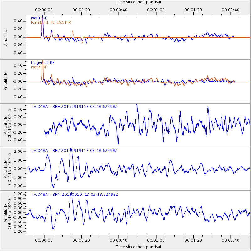
O48A Farmland, IN, USA - Earthquake Result Viewer
*The percent match for this event was below the threshold and hence no stack was calculated.
| Earthquake location: |
Off Coast Of Central Chile |
| Earthquake latitude/longitude: |
-32.3/-72.1 |
| Earthquake time(UTC): |
2015/09/19 (262) 12:52:19 GMT |
| Earthquake Depth: |
11 km |
| Earthquake Magnitude: |
6.2 MWB |
| Earthquake Catalog/Contributor: |
NEIC PDE/NEIC COMCAT |
|
| Network: |
TA USArray Transportable Network (new EarthScope stations) |
| Station: |
O48A Farmland, IN, USA |
| Lat/Lon: |
40.26 N/85.16 W |
| Elevation: |
300 m |
|
| Distance: |
73.2 deg |
| Az: |
349.592 deg |
| Baz: |
168.472 deg |
| Ray Param: |
$rayparam |
*The percent match for this event was below the threshold and hence was not used in the summary stack. |
|
| Radial Match: |
71.14751 % |
| Radial Bump: |
400 |
| Transverse Match: |
56.815327 % |
| Transverse Bump: |
400 |
| SOD ConfigId: |
7422571 |
| Insert Time: |
2019-04-20 22:53:29.152 +0000 |
| GWidth: |
2.5 |
| Max Bumps: |
400 |
| Tol: |
0.001 |
|
Signal To Noise
| Channel | StoN | STA | LTA |
| TA:O48A: :BHZ:20150919T13:03:18.62498Z | 8.223147 | 1.1004975E-6 | 1.3382922E-7 |
| TA:O48A: :BHN:20150919T13:03:18.62498Z | 2.120527 | 4.6609816E-7 | 2.1980296E-7 |
| TA:O48A: :BHE:20150919T13:03:18.62498Z | 1.5384723 | 1.6516634E-7 | 1.07357366E-7 |
| Arrivals |
| Ps | |
| PpPs | |
| PsPs/PpSs | |


