You are here: Home > Network List > TA - USArray Transportable Network (new EarthScope stations) Stations List
> Station Q61A Milford, DE, USA > Earthquake Result Viewer
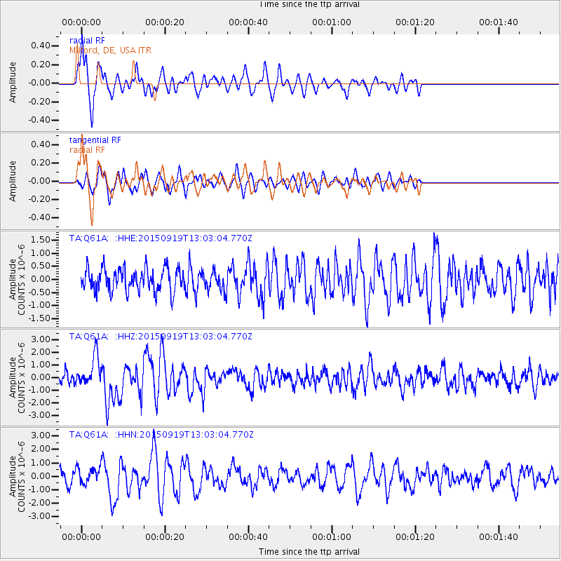
Q61A Milford, DE, USA - Earthquake Result Viewer
*The percent match for this event was below the threshold and hence no stack was calculated.
| Earthquake location: |
Off Coast Of Central Chile |
| Earthquake latitude/longitude: |
-32.3/-72.1 |
| Earthquake time(UTC): |
2015/09/19 (262) 12:52:19 GMT |
| Earthquake Depth: |
11 km |
| Earthquake Magnitude: |
6.2 MWB |
| Earthquake Catalog/Contributor: |
NEIC PDE/NEIC COMCAT |
|
| Network: |
TA USArray Transportable Network (new EarthScope stations) |
| Station: |
Q61A Milford, DE, USA |
| Lat/Lon: |
38.88 N/75.33 W |
| Elevation: |
5.0 m |
|
| Distance: |
70.9 deg |
| Az: |
357.329 deg |
| Baz: |
177.103 deg |
| Ray Param: |
$rayparam |
*The percent match for this event was below the threshold and hence was not used in the summary stack. |
|
| Radial Match: |
76.74 % |
| Radial Bump: |
369 |
| Transverse Match: |
62.648563 % |
| Transverse Bump: |
400 |
| SOD ConfigId: |
7422571 |
| Insert Time: |
2019-04-20 22:53:34.497 +0000 |
| GWidth: |
2.5 |
| Max Bumps: |
400 |
| Tol: |
0.001 |
|
Signal To Noise
| Channel | StoN | STA | LTA |
| TA:Q61A: :HHZ:20150919T13:03:04.770Z | 2.8155112 | 1.2195035E-6 | 4.3313747E-7 |
| TA:Q61A: :HHN:20150919T13:03:04.770Z | 1.0351214 | 6.2738366E-7 | 6.0609665E-7 |
| TA:Q61A: :HHE:20150919T13:03:04.770Z | 0.8518447 | 3.759571E-7 | 4.413446E-7 |
| Arrivals |
| Ps | |
| PpPs | |
| PsPs/PpSs | |


