You are here: Home > Network List > TA - USArray Transportable Network (new EarthScope stations) Stations List
> Station TUL1 Leonard, OK, USA > Earthquake Result Viewer
TUL1 Leonard, OK, USA - Earthquake Result Viewer
| Earthquake location: |
Off Coast Of Central Chile |
| Earthquake latitude/longitude: |
-32.3/-72.1 |
| Earthquake time(UTC): |
2015/09/19 (262) 12:52:19 GMT |
| Earthquake Depth: |
11 km |
| Earthquake Magnitude: |
6.2 MWB |
| Earthquake Catalog/Contributor: |
NEIC PDE/NEIC COMCAT |
|
| Network: |
TA USArray Transportable Network (new EarthScope stations) |
| Station: |
TUL1 Leonard, OK, USA |
| Lat/Lon: |
35.91 N/95.79 W |
| Elevation: |
256 m |
|
| Distance: |
71.4 deg |
| Az: |
339.865 deg |
| Baz: |
158.963 deg |
| Ray Param: |
0.054331865 |
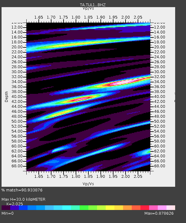
| Estimated Moho Depth: |
33.0 km |
| Estimated Crust Vp/Vs: |
2.03 |
| Assumed Crust Vp: |
6.498 km/s |
| Estimated Crust Vs: |
3.209 km/s |
| Estimated Crust Poisson's Ratio: |
0.34 |
|
| Radial Match: |
90.933876 % |
| Radial Bump: |
395 |
| Transverse Match: |
71.1792 % |
| Transverse Bump: |
400 |
| SOD ConfigId: |
7422571 |
| Insert Time: |
2019-04-20 22:53:39.460 +0000 |
| GWidth: |
2.5 |
| Max Bumps: |
400 |
| Tol: |
0.001 |
|

Signal To Noise
| Channel | StoN | STA | LTA |
| TA:TUL1: :BHZ:20150919T13:03:07.925029Z | 6.7041492 | 5.1135004E-7 | 7.6273665E-8 |
| TA:TUL1: :BHN:20150919T13:03:07.925029Z | 2.6572878 | 2.2198816E-7 | 8.3539376E-8 |
| TA:TUL1: :BHE:20150919T13:03:07.925029Z | 1.2047129 | 7.0568596E-8 | 5.8577108E-8 |
| Arrivals |
| Ps | 5.4 SECOND |
| PpPs | 15 SECOND |
| PsPs/PpSs | 20 SECOND |


