You are here: Home > Network List > TA - USArray Transportable Network (new EarthScope stations) Stations List
> Station W41B Gary Mavity, Velonia, AR, USA > Earthquake Result Viewer
W41B Gary Mavity, Velonia, AR, USA - Earthquake Result Viewer
| Earthquake location: |
Off Coast Of Central Chile |
| Earthquake latitude/longitude: |
-32.3/-72.1 |
| Earthquake time(UTC): |
2015/09/19 (262) 12:52:19 GMT |
| Earthquake Depth: |
11 km |
| Earthquake Magnitude: |
6.2 MWB |
| Earthquake Catalog/Contributor: |
NEIC PDE/NEIC COMCAT |
|
| Network: |
TA USArray Transportable Network (new EarthScope stations) |
| Station: |
W41B Gary Mavity, Velonia, AR, USA |
| Lat/Lon: |
35.17 N/92.25 W |
| Elevation: |
95 m |
|
| Distance: |
69.8 deg |
| Az: |
342.491 deg |
| Baz: |
161.887 deg |
| Ray Param: |
0.05542519 |
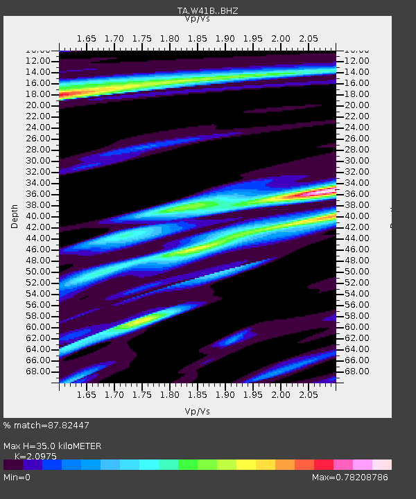
| Estimated Moho Depth: |
35.0 km |
| Estimated Crust Vp/Vs: |
2.10 |
| Assumed Crust Vp: |
6.498 km/s |
| Estimated Crust Vs: |
3.098 km/s |
| Estimated Crust Poisson's Ratio: |
0.35 |
|
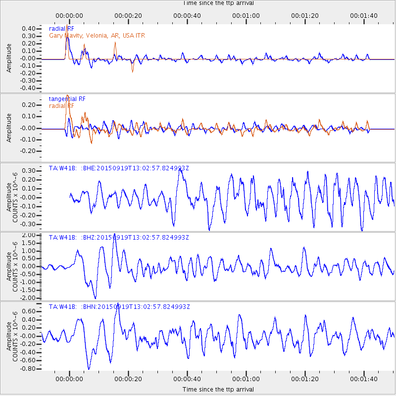
| Radial Match: |
87.82447 % |
| Radial Bump: |
400 |
| Transverse Match: |
69.9979 % |
| Transverse Bump: |
400 |
| SOD ConfigId: |
7422571 |
| Insert Time: |
2019-04-20 22:53:41.482 +0000 |
| GWidth: |
2.5 |
| Max Bumps: |
400 |
| Tol: |
0.001 |
|
Signal To Noise
| Channel | StoN | STA | LTA |
| TA:W41B: :BHZ:20150919T13:02:57.824993Z | 5.625373 | 5.428577E-7 | 9.6501644E-8 |
| TA:W41B: :BHN:20150919T13:02:57.824993Z | 3.463065 | 2.7856422E-7 | 8.043863E-8 |
| TA:W41B: :BHE:20150919T13:02:57.824993Z | 1.7866703 | 1.3435134E-7 | 7.519649E-8 |
| Arrivals |
| Ps | 6.1 SECOND |
| PpPs | 16 SECOND |
| PsPs/PpSs | 22 SECOND |


