You are here: Home > Network List > IU - Global Seismograph Network (GSN - IRIS/USGS) Stations List
> Station COL College Outpost, Alaska, USA > Earthquake Result Viewer
COL College Outpost, Alaska, USA - Earthquake Result Viewer
| Earthquake location: |
Samoa Islands Region |
| Earthquake latitude/longitude: |
-16.7/-172.8 |
| Earthquake time(UTC): |
1993/07/20 (201) 07:38:18 GMT |
| Earthquake Depth: |
32 km |
| Earthquake Magnitude: |
5.2 MB, 5.8 MS |
| Earthquake Catalog/Contributor: |
WHDF/NEIC |
|
| Network: |
IU Global Seismograph Network (GSN - IRIS/USGS) |
| Station: |
COL College Outpost, Alaska, USA |
| Lat/Lon: |
64.90 N/147.79 W |
| Elevation: |
320 m |
|
| Distance: |
83.5 deg |
| Az: |
10.464 deg |
| Baz: |
204.085 deg |
| Ray Param: |
0.04607023 |
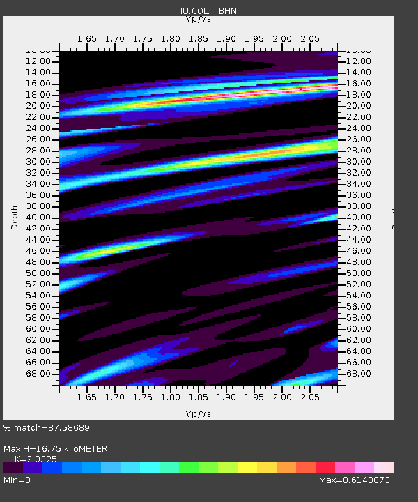
| Estimated Moho Depth: |
16.75 km |
| Estimated Crust Vp/Vs: |
2.03 |
| Assumed Crust Vp: |
6.566 km/s |
| Estimated Crust Vs: |
3.231 km/s |
| Estimated Crust Poisson's Ratio: |
0.34 |
|
| Radial Match: |
87.58689 % |
| Radial Bump: |
335 |
| Transverse Match: |
78.47566 % |
| Transverse Bump: |
400 |
| SOD ConfigId: |
17000 |
| Insert Time: |
2010-03-04 20:17:26.846 +0000 |
| GWidth: |
2.5 |
| Max Bumps: |
400 |
| Tol: |
0.001 |
|

Signal To Noise
| Channel | StoN | STA | LTA |
| IU:COL: :BHN:19930720T07:50:12.425Z | 2.8166091 | 2.103781E-7 | 7.4691975E-8 |
| IU:COL: :BHE:19930720T07:50:12.425Z | 1.0397339 | 7.5071014E-8 | 7.220215E-8 |
| IU:COL: :BHZ:19930720T07:50:12.425Z | 6.042728 | 4.005367E-7 | 6.628408E-8 |
| Arrivals |
| Ps | 2.7 SECOND |
| PpPs | 7.6 SECOND |
| PsPs/PpSs | 10 SECOND |


