You are here: Home > Network List > 7A - Mid-Atlantic Geophysical Integrative Collaboration Stations List
> Station JSPR Franklin, West Virginia USA > Earthquake Result Viewer
JSPR Franklin, West Virginia USA - Earthquake Result Viewer
| Earthquake location: |
Near Coast Of Central Chile |
| Earthquake latitude/longitude: |
-31.6/-71.7 |
| Earthquake time(UTC): |
2015/09/21 (264) 05:39:33 GMT |
| Earthquake Depth: |
23 km |
| Earthquake Magnitude: |
6.3 MWP |
| Earthquake Catalog/Contributor: |
NEIC PDE/NEIC COMCAT |
|
| Network: |
7A Mid-Atlantic Geophysical Integrative Collaboration |
| Station: |
JSPR Franklin, West Virginia USA |
| Lat/Lon: |
38.64 N/79.33 W |
| Elevation: |
527 m |
|
| Distance: |
70.2 deg |
| Az: |
353.664 deg |
| Baz: |
173.092 deg |
| Ray Param: |
0.05509869 |
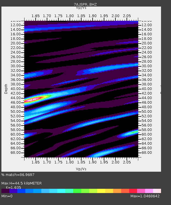
| Estimated Moho Depth: |
44.5 km |
| Estimated Crust Vp/Vs: |
1.63 |
| Assumed Crust Vp: |
6.159 km/s |
| Estimated Crust Vs: |
3.767 km/s |
| Estimated Crust Poisson's Ratio: |
0.20 |
|
| Radial Match: |
86.9697 % |
| Radial Bump: |
400 |
| Transverse Match: |
68.03865 % |
| Transverse Bump: |
400 |
| SOD ConfigId: |
7422571 |
| Insert Time: |
2019-04-20 23:04:04.309 +0000 |
| GWidth: |
2.5 |
| Max Bumps: |
400 |
| Tol: |
0.001 |
|

Signal To Noise
| Channel | StoN | STA | LTA |
| 7A:JSPR: :BHZ:20150921T05:50:13.03999Z | 14.210367 | 1.476935E-6 | 1.0393363E-7 |
| 7A:JSPR: :BHN:20150921T05:50:13.03999Z | 5.3338327 | 6.544494E-7 | 1.2269778E-7 |
| 7A:JSPR: :BHE:20150921T05:50:13.03999Z | 1.5471458 | 1.7216226E-7 | 1.1127732E-7 |
| Arrivals |
| Ps | 4.8 SECOND |
| PpPs | 18 SECOND |
| PsPs/PpSs | 23 SECOND |


