You are here: Home > Network List > IU - Global Seismograph Network (GSN - IRIS/USGS) Stations List
> Station COL College Outpost, Alaska, USA > Earthquake Result Viewer
COL College Outpost, Alaska, USA - Earthquake Result Viewer
| Earthquake location: |
Bonin Islands, Japan Region |
| Earthquake latitude/longitude: |
29.0/138.9 |
| Earthquake time(UTC): |
1996/03/16 (076) 22:04:06 GMT |
| Earthquake Depth: |
477 km |
| Earthquake Magnitude: |
5.9 MB, 6.6 UNKNOWN, 6.1 MB |
| Earthquake Catalog/Contributor: |
WHDF/NEIC |
|
| Network: |
IU Global Seismograph Network (GSN - IRIS/USGS) |
| Station: |
COL College Outpost, Alaska, USA |
| Lat/Lon: |
64.90 N/147.79 W |
| Elevation: |
320 m |
|
| Distance: |
57.1 deg |
| Az: |
29.122 deg |
| Baz: |
268.458 deg |
| Ray Param: |
0.06186117 |
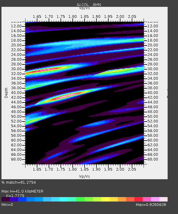
| Estimated Moho Depth: |
41.0 km |
| Estimated Crust Vp/Vs: |
1.78 |
| Assumed Crust Vp: |
6.566 km/s |
| Estimated Crust Vs: |
3.694 km/s |
| Estimated Crust Poisson's Ratio: |
0.27 |
|
| Radial Match: |
91.2754 % |
| Radial Bump: |
400 |
| Transverse Match: |
84.00994 % |
| Transverse Bump: |
400 |
| SOD ConfigId: |
6273 |
| Insert Time: |
2010-03-04 20:20:54.349 +0000 |
| GWidth: |
2.5 |
| Max Bumps: |
400 |
| Tol: |
0.001 |
|

Signal To Noise
| Channel | StoN | STA | LTA |
| IU:COL: :BHN:19960316T22:12:35.175006Z | 1.5160941 | 3.824177E-7 | 2.5223878E-7 |
| IU:COL: :BHE:19960316T22:12:35.176013Z | 6.7152576 | 1.5167437E-6 | 2.258653E-7 |
| IU:COL: :BHZ:19960316T22:12:35.175006Z | 32.217808 | 3.62165E-6 | 1.1241143E-7 |
| Arrivals |
| Ps | 5.1 SECOND |
| PpPs | 17 SECOND |
| PsPs/PpSs | 22 SECOND |


