You are here: Home > Network List > TA - USArray Transportable Network (new EarthScope stations) Stations List
> Station H17A Grant Village (NPS), Yellowstone Nt. Park, WY, USA > Earthquake Result Viewer
H17A Grant Village (NPS), Yellowstone Nt. Park, WY, USA - Earthquake Result Viewer

| Earthquake location: |
Near Coast Of Central Chile |
| Earthquake latitude/longitude: |
-31.6/-71.7 |
| Earthquake time(UTC): |
2015/09/21 (264) 05:39:33 GMT |
| Earthquake Depth: |
23 km |
| Earthquake Magnitude: |
6.3 MWP |
| Earthquake Catalog/Contributor: |
NEIC PDE/NEIC COMCAT |
|
| Network: |
TA USArray Transportable Network (new EarthScope stations) |
| Station: |
H17A Grant Village (NPS), Yellowstone Nt. Park, WY, USA |
| Lat/Lon: |
44.40 N/110.58 W |
| Elevation: |
2400 m |
|
| Distance: |
83.5 deg |
| Az: |
333.081 deg |
| Baz: |
147.387 deg |
| Ray Param: |
0.04611121 |
| Estimated Moho Depth: |
29.0 km |
| Estimated Crust Vp/Vs: |
1.60 |
| Assumed Crust Vp: |
6.35 km/s |
| Estimated Crust Vs: |
3.969 km/s |
| Estimated Crust Poisson's Ratio: |
0.18 |
|
| Radial Match: |
84.529625 % |
| Radial Bump: |
400 |
| Transverse Match: |
82.34247 % |
| Transverse Bump: |
400 |
| SOD ConfigId: |
7422571 |
| Insert Time: |
2019-04-20 23:12:17.035 +0000 |
| GWidth: |
2.5 |
| Max Bumps: |
400 |
| Tol: |
0.001 |
|
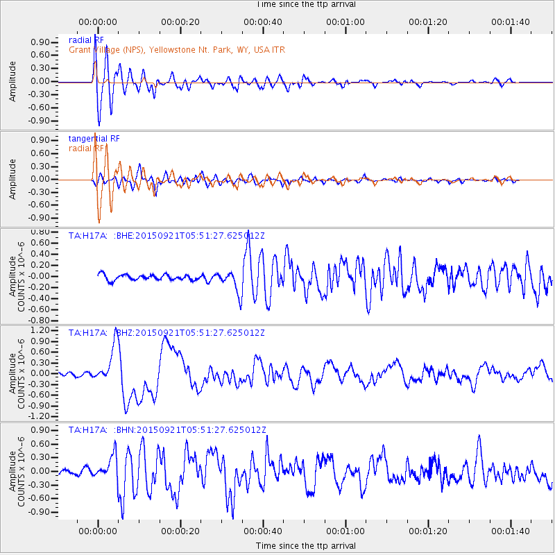
Signal To Noise
| Channel | StoN | STA | LTA |
| TA:H17A: :BHZ:20150921T05:51:27.625012Z | 11.685622 | 5.6604347E-7 | 4.843931E-8 |
| TA:H17A: :BHN:20150921T05:51:27.625012Z | 4.7953324 | 2.7784105E-7 | 5.79399E-8 |
| TA:H17A: :BHE:20150921T05:51:27.625012Z | 4.4179134 | 2.168413E-7 | 4.908229E-8 |
| Arrivals |
| Ps | 2.8 SECOND |
| PpPs | 12 SECOND |
| PsPs/PpSs | 14 SECOND |


