You are here: Home > Network List > IU - Global Seismograph Network (GSN - IRIS/USGS) Stations List
> Station COL College Outpost, Alaska, USA > Earthquake Result Viewer
COL College Outpost, Alaska, USA - Earthquake Result Viewer
| Earthquake location: |
Irian Jaya Region, Indonesia |
| Earthquake latitude/longitude: |
-0.9/137.0 |
| Earthquake time(UTC): |
1996/02/17 (048) 05:59:29 GMT |
| Earthquake Depth: |
33 km |
| Earthquake Magnitude: |
6.5 MB, 8.1 MS, 7.9 UNKNOWN |
| Earthquake Catalog/Contributor: |
WHDF/NEIC |
|
| Network: |
IU Global Seismograph Network (GSN - IRIS/USGS) |
| Station: |
COL College Outpost, Alaska, USA |
| Lat/Lon: |
64.90 N/147.79 W |
| Elevation: |
320 m |
|
| Distance: |
84.6 deg |
| Az: |
24.468 deg |
| Baz: |
256.148 deg |
| Ray Param: |
0.045326382 |
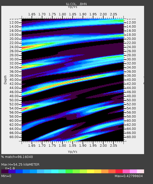
| Estimated Moho Depth: |
54.25 km |
| Estimated Crust Vp/Vs: |
1.60 |
| Assumed Crust Vp: |
6.566 km/s |
| Estimated Crust Vs: |
4.104 km/s |
| Estimated Crust Poisson's Ratio: |
0.18 |
|
| Radial Match: |
96.16048 % |
| Radial Bump: |
400 |
| Transverse Match: |
85.18371 % |
| Transverse Bump: |
400 |
| SOD ConfigId: |
6273 |
| Insert Time: |
2010-03-04 20:21:05.338 +0000 |
| GWidth: |
2.5 |
| Max Bumps: |
400 |
| Tol: |
0.001 |
|

Signal To Noise
| Channel | StoN | STA | LTA |
| IU:COL: :BHN:19960217T06:11:28.522021Z | 1.492593 | 1.7517928E-7 | 1.17365744E-7 |
| IU:COL: :BHE:19960217T06:11:28.522021Z | 3.7495522 | 4.3093317E-7 | 1.14929236E-7 |
| IU:COL: :BHZ:19960217T06:11:28.522021Z | 5.8282485 | 1.1864857E-6 | 2.0357501E-7 |
| Arrivals |
| Ps | 5.1 SECOND |
| PpPs | 21 SECOND |
| PsPs/PpSs | 26 SECOND |


