You are here: Home > Network List > TA - USArray Transportable Network (new EarthScope stations) Stations List
> Station Q24A Divide, CO, USA > Earthquake Result Viewer
Q24A Divide, CO, USA - Earthquake Result Viewer
| Earthquake location: |
Near Coast Of Central Chile |
| Earthquake latitude/longitude: |
-31.6/-71.7 |
| Earthquake time(UTC): |
2015/09/21 (264) 05:39:33 GMT |
| Earthquake Depth: |
23 km |
| Earthquake Magnitude: |
6.3 MWP |
| Earthquake Catalog/Contributor: |
NEIC PDE/NEIC COMCAT |
|
| Network: |
TA USArray Transportable Network (new EarthScope stations) |
| Station: |
Q24A Divide, CO, USA |
| Lat/Lon: |
38.96 N/105.15 W |
| Elevation: |
2775 m |
|
| Distance: |
76.8 deg |
| Az: |
333.814 deg |
| Baz: |
151.114 deg |
| Ray Param: |
0.05074342 |
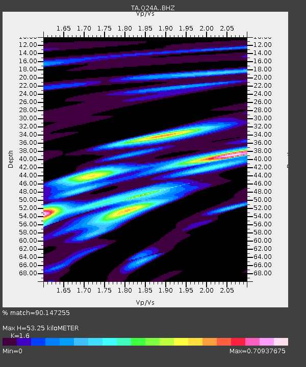
| Estimated Moho Depth: |
53.25 km |
| Estimated Crust Vp/Vs: |
1.60 |
| Assumed Crust Vp: |
6.159 km/s |
| Estimated Crust Vs: |
3.849 km/s |
| Estimated Crust Poisson's Ratio: |
0.18 |
|
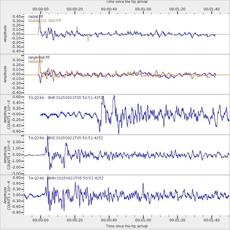
| Radial Match: |
90.147255 % |
| Radial Bump: |
400 |
| Transverse Match: |
77.949234 % |
| Transverse Bump: |
400 |
| SOD ConfigId: |
7422571 |
| Insert Time: |
2019-04-20 23:12:52.835 +0000 |
| GWidth: |
2.5 |
| Max Bumps: |
400 |
| Tol: |
0.001 |
|
Signal To Noise
| Channel | StoN | STA | LTA |
| TA:Q24A: :BHZ:20150921T05:50:51.425Z | 13.879154 | 8.7307166E-7 | 6.290525E-8 |
| TA:Q24A: :BHN:20150921T05:50:51.425Z | 5.2026668 | 2.879184E-7 | 5.5340543E-8 |
| TA:Q24A: :BHE:20150921T05:50:51.425Z | 4.018026 | 2.1016474E-7 | 5.230547E-8 |
| Arrivals |
| Ps | 5.4 SECOND |
| PpPs | 22 SECOND |
| PsPs/PpSs | 27 SECOND |


