You are here: Home > Network List > TA - USArray Transportable Network (new EarthScope stations) Stations List
> Station R11A Troy Canyon, Currant, NV, USA > Earthquake Result Viewer
R11A Troy Canyon, Currant, NV, USA - Earthquake Result Viewer
| Earthquake location: |
Near Coast Of Central Chile |
| Earthquake latitude/longitude: |
-31.6/-71.7 |
| Earthquake time(UTC): |
2015/09/21 (264) 05:39:33 GMT |
| Earthquake Depth: |
23 km |
| Earthquake Magnitude: |
6.3 MWP |
| Earthquake Catalog/Contributor: |
NEIC PDE/NEIC COMCAT |
|
| Network: |
TA USArray Transportable Network (new EarthScope stations) |
| Station: |
R11A Troy Canyon, Currant, NV, USA |
| Lat/Lon: |
38.35 N/115.59 W |
| Elevation: |
1756 m |
|
| Distance: |
80.7 deg |
| Az: |
326.482 deg |
| Baz: |
143.175 deg |
| Ray Param: |
0.04807771 |
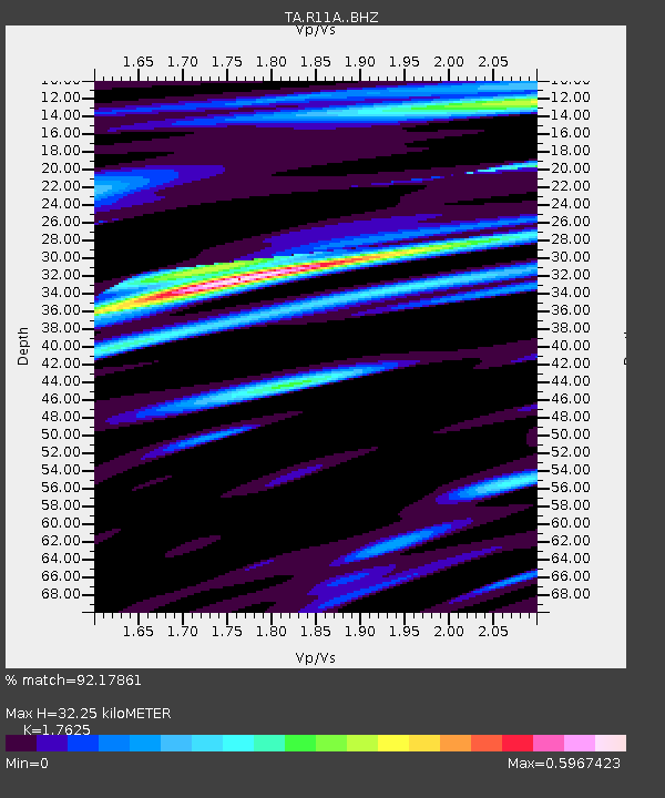
| Estimated Moho Depth: |
32.25 km |
| Estimated Crust Vp/Vs: |
1.76 |
| Assumed Crust Vp: |
6.276 km/s |
| Estimated Crust Vs: |
3.561 km/s |
| Estimated Crust Poisson's Ratio: |
0.26 |
|
| Radial Match: |
92.17861 % |
| Radial Bump: |
400 |
| Transverse Match: |
81.37068 % |
| Transverse Bump: |
400 |
| SOD ConfigId: |
7422571 |
| Insert Time: |
2019-04-20 23:12:53.739 +0000 |
| GWidth: |
2.5 |
| Max Bumps: |
400 |
| Tol: |
0.001 |
|
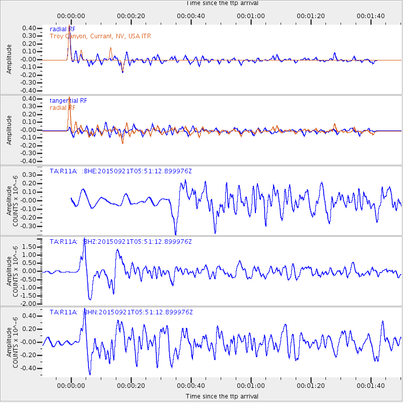
Signal To Noise
| Channel | StoN | STA | LTA |
| TA:R11A: :BHZ:20150921T05:51:12.899976Z | 16.962782 | 7.388967E-7 | 4.3559876E-8 |
| TA:R11A: :BHN:20150921T05:51:12.899976Z | 3.953606 | 1.8922825E-7 | 4.7862194E-8 |
| TA:R11A: :BHE:20150921T05:51:12.899976Z | 3.0132186 | 1.5150066E-7 | 5.027868E-8 |
| Arrivals |
| Ps | 4.0 SECOND |
| PpPs | 14 SECOND |
| PsPs/PpSs | 18 SECOND |


