You are here: Home > Network List > IU - Global Seismograph Network (GSN - IRIS/USGS) Stations List
> Station COL College Outpost, Alaska, USA > Earthquake Result Viewer
COL College Outpost, Alaska, USA - Earthquake Result Viewer
| Earthquake location: |
Kuril Islands |
| Earthquake latitude/longitude: |
43.7/147.6 |
| Earthquake time(UTC): |
1996/05/07 (128) 23:20:00 GMT |
| Earthquake Depth: |
54 km |
| Earthquake Magnitude: |
6.2 MB, 5.6 MS, 6.2 UNKNOWN, 5.2 MS |
| Earthquake Catalog/Contributor: |
WHDF/NEIC |
|
| Network: |
IU Global Seismograph Network (GSN - IRIS/USGS) |
| Station: |
COL College Outpost, Alaska, USA |
| Lat/Lon: |
64.90 N/147.79 W |
| Elevation: |
320 m |
|
| Distance: |
40.9 deg |
| Az: |
36.021 deg |
| Baz: |
271.08 deg |
| Ray Param: |
0.073953666 |
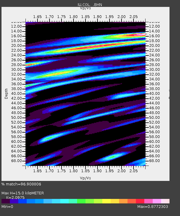
| Estimated Moho Depth: |
15.0 km |
| Estimated Crust Vp/Vs: |
2.10 |
| Assumed Crust Vp: |
6.566 km/s |
| Estimated Crust Vs: |
3.13 km/s |
| Estimated Crust Poisson's Ratio: |
0.35 |
|
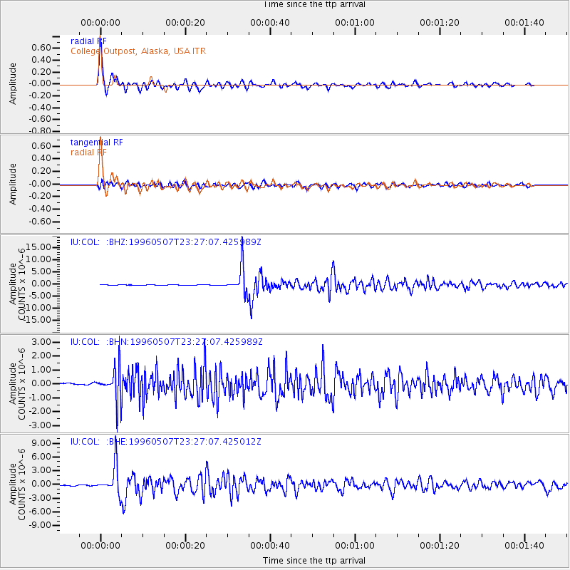
| Radial Match: |
96.908806 % |
| Radial Bump: |
400 |
| Transverse Match: |
78.08561 % |
| Transverse Bump: |
400 |
| SOD ConfigId: |
6273 |
| Insert Time: |
2010-03-04 20:21:31.268 +0000 |
| GWidth: |
2.5 |
| Max Bumps: |
400 |
| Tol: |
0.001 |
|
Signal To Noise
| Channel | StoN | STA | LTA |
| IU:COL: :BHN:19960507T23:27:07.425989Z | 9.026151 | 1.2325056E-6 | 1.3654831E-7 |
| IU:COL: :BHE:19960507T23:27:07.425012Z | 41.934925 | 3.265146E-6 | 7.786221E-8 |
| IU:COL: :BHZ:19960507T23:27:07.425989Z | 59.689186 | 5.747744E-6 | 9.629456E-8 |
| Arrivals |
| Ps | 2.7 SECOND |
| PpPs | 6.7 SECOND |
| PsPs/PpSs | 9.3 SECOND |


