You are here: Home > Network List > IU - Global Seismograph Network (GSN - IRIS/USGS) Stations List
> Station KMBO Kilima Mbogo, Kenya > Earthquake Result Viewer
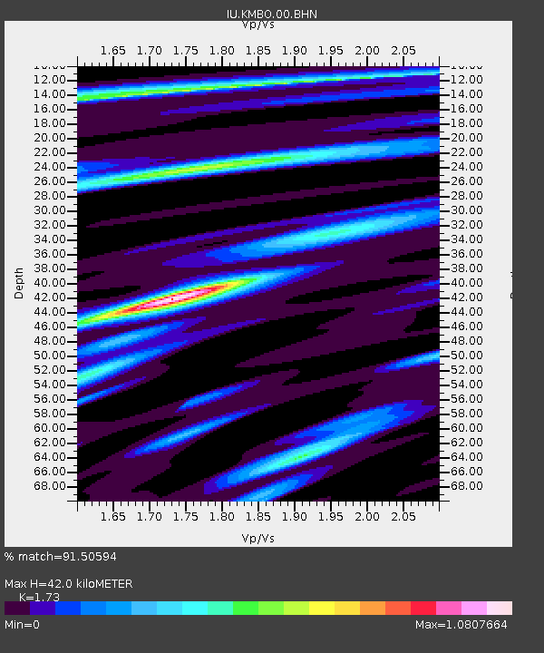
KMBO Kilima Mbogo, Kenya - Earthquake Result Viewer
| Earthquake location: |
Hindu Kush Region, Afghanistan |
| Earthquake latitude/longitude: |
36.0/70.7 |
| Earthquake time(UTC): |
2000/05/12 (133) 23:10:29 GMT |
| Earthquake Depth: |
108 km |
| Earthquake Magnitude: |
6.2 MB, 6.3 MW, 6.3 MW |
| Earthquake Catalog/Contributor: |
WHDF/NEIC |
|
| Network: |
IU Global Seismograph Network (GSN - IRIS/USGS) |
| Station: |
KMBO Kilima Mbogo, Kenya |
| Lat/Lon: |
1.13 S/37.25 E |
| Elevation: |
1960 m |
|
| Distance: |
48.3 deg |
| Az: |
227.523 deg |
| Baz: |
36.753 deg |
| Ray Param: |
0.06910021 |
| Estimated Moho Depth: |
42.0 km |
| Estimated Crust Vp/Vs: |
1.73 |
| Assumed Crust Vp: |
6.601 km/s |
| Estimated Crust Vs: |
3.815 km/s |
| Estimated Crust Poisson's Ratio: |
0.25 |
|
| Radial Match: |
91.50594 % |
| Radial Bump: |
353 |
| Transverse Match: |
84.61248 % |
| Transverse Bump: |
400 |
| SOD ConfigId: |
3744 |
| Insert Time: |
2010-03-04 20:22:12.669 +0000 |
| GWidth: |
2.5 |
| Max Bumps: |
400 |
| Tol: |
0.001 |
|

Signal To Noise
| Channel | StoN | STA | LTA |
| IU:KMBO:00:BHN:20000512T23:18:29.658986Z | 3.2580397 | 1.659164E-7 | 5.0925227E-8 |
| IU:KMBO:00:BHE:20000512T23:18:29.658986Z | 3.421062 | 9.1260205E-8 | 2.6675986E-8 |
| IU:KMBO:00:BHZ:20000512T23:18:29.658986Z | 5.37422 | 3.2753664E-7 | 6.0945894E-8 |
| Arrivals |
| Ps | 5.0 SECOND |
| PpPs | 16 SECOND |
| PsPs/PpSs | 21 SECOND |


