You are here: Home > Network List > IU - Global Seismograph Network (GSN - IRIS/USGS) Stations List
> Station KMBO Kilima Mbogo, Kenya > Earthquake Result Viewer
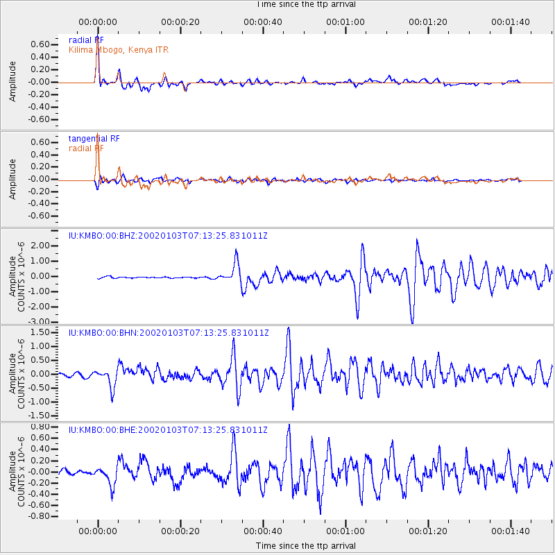
KMBO Kilima Mbogo, Kenya - Earthquake Result Viewer

| Earthquake location: |
Hindu Kush Region, Afghanistan |
| Earthquake latitude/longitude: |
36.1/70.7 |
| Earthquake time(UTC): |
2002/01/03 (003) 07:05:27 GMT |
| Earthquake Depth: |
129 km |
| Earthquake Magnitude: |
5.8 MB, 6.2 MW, 6.1 MW |
| Earthquake Catalog/Contributor: |
WHDF/NEIC |
|
| Network: |
IU Global Seismograph Network (GSN - IRIS/USGS) |
| Station: |
KMBO Kilima Mbogo, Kenya |
| Lat/Lon: |
1.13 S/37.25 E |
| Elevation: |
1960 m |
|
| Distance: |
48.4 deg |
| Az: |
227.481 deg |
| Baz: |
36.664 deg |
| Ray Param: |
0.06894753 |
| Estimated Moho Depth: |
42.0 km |
| Estimated Crust Vp/Vs: |
1.75 |
| Assumed Crust Vp: |
6.601 km/s |
| Estimated Crust Vs: |
3.777 km/s |
| Estimated Crust Poisson's Ratio: |
0.26 |
|
| Radial Match: |
94.26041 % |
| Radial Bump: |
393 |
| Transverse Match: |
77.88362 % |
| Transverse Bump: |
400 |
| SOD ConfigId: |
20082 |
| Insert Time: |
2010-03-04 20:22:57.866 +0000 |
| GWidth: |
2.5 |
| Max Bumps: |
400 |
| Tol: |
0.001 |
|
Signal To Noise
| Channel | StoN | STA | LTA |
| IU:KMBO:00:BHN:20020103T07:13:25.831011Z | 5.0685935 | 3.414408E-7 | 6.736401E-8 |
| IU:KMBO:00:BHE:20020103T07:13:25.831011Z | 2.6321912 | 1.6947084E-7 | 6.438394E-8 |
| IU:KMBO:00:BHZ:20020103T07:13:25.831011Z | 16.227728 | 6.5392504E-7 | 4.029677E-8 |
| Arrivals |
| Ps | 5.1 SECOND |
| PpPs | 16 SECOND |
| PsPs/PpSs | 21 SECOND |


