You are here: Home > Network List > IU - Global Seismograph Network (GSN - IRIS/USGS) Stations List
> Station KMBO Kilima Mbogo, Kenya > Earthquake Result Viewer
KMBO Kilima Mbogo, Kenya - Earthquake Result Viewer
| Earthquake location: |
Qinghai, China |
| Earthquake latitude/longitude: |
37.5/96.5 |
| Earthquake time(UTC): |
2003/04/17 (107) 00:48:38 GMT |
| Earthquake Depth: |
14 km |
| Earthquake Magnitude: |
6.2 MB, 6.3 MS, 6.4 MW, 6.2 MW |
| Earthquake Catalog/Contributor: |
WHDF/NEIC |
|
| Network: |
IU Global Seismograph Network (GSN - IRIS/USGS) |
| Station: |
KMBO Kilima Mbogo, Kenya |
| Lat/Lon: |
1.13 S/37.25 E |
| Elevation: |
1960 m |
|
| Distance: |
66.7 deg |
| Az: |
249.226 deg |
| Baz: |
48.028 deg |
| Ray Param: |
0.057406023 |
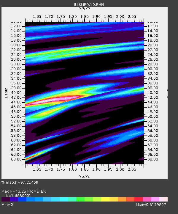
| Estimated Moho Depth: |
43.25 km |
| Estimated Crust Vp/Vs: |
1.69 |
| Assumed Crust Vp: |
6.601 km/s |
| Estimated Crust Vs: |
3.917 km/s |
| Estimated Crust Poisson's Ratio: |
0.23 |
|
| Radial Match: |
97.21409 % |
| Radial Bump: |
344 |
| Transverse Match: |
83.761955 % |
| Transverse Bump: |
400 |
| SOD ConfigId: |
4714 |
| Insert Time: |
2010-03-04 20:23:03.219 +0000 |
| GWidth: |
2.5 |
| Max Bumps: |
400 |
| Tol: |
0.001 |
|

Signal To Noise
| Channel | StoN | STA | LTA |
| IU:KMBO:10:BHN:20030417T00:58:58.035017Z | 2.4750988 | 1.9326102E-7 | 7.808214E-8 |
| IU:KMBO:10:BHE:20030417T00:58:58.035017Z | 1.9947119 | 1.1874956E-7 | 5.953219E-8 |
| IU:KMBO:10:BHZ:20030417T00:58:58.035017Z | 4.4591074 | 3.327057E-7 | 7.461262E-8 |
| Arrivals |
| Ps | 4.7 SECOND |
| PpPs | 17 SECOND |
| PsPs/PpSs | 22 SECOND |


