You are here: Home > Network List > IU - Global Seismograph Network (GSN - IRIS/USGS) Stations List
> Station KMBO Kilima Mbogo, Kenya > Earthquake Result Viewer
KMBO Kilima Mbogo, Kenya - Earthquake Result Viewer
| Earthquake location: |
Halmahera, Indonesia |
| Earthquake latitude/longitude: |
1.7/127.3 |
| Earthquake time(UTC): |
2003/03/10 (069) 02:09:37 GMT |
| Earthquake Depth: |
94 km |
| Earthquake Magnitude: |
6.2 MB, 6.4 MW, 6.4 MW |
| Earthquake Catalog/Contributor: |
WHDF/NEIC |
|
| Network: |
IU Global Seismograph Network (GSN - IRIS/USGS) |
| Station: |
KMBO Kilima Mbogo, Kenya |
| Lat/Lon: |
1.13 S/37.25 E |
| Elevation: |
1960 m |
|
| Distance: |
90.1 deg |
| Az: |
268.883 deg |
| Baz: |
88.32 deg |
| Ray Param: |
0.041681103 |
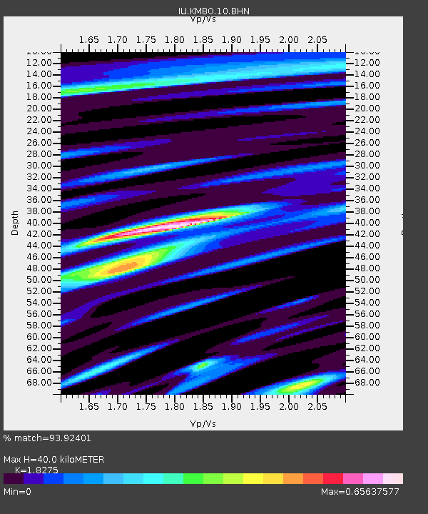
| Estimated Moho Depth: |
40.0 km |
| Estimated Crust Vp/Vs: |
1.83 |
| Assumed Crust Vp: |
6.601 km/s |
| Estimated Crust Vs: |
3.612 km/s |
| Estimated Crust Poisson's Ratio: |
0.29 |
|
| Radial Match: |
93.92401 % |
| Radial Bump: |
335 |
| Transverse Match: |
74.47093 % |
| Transverse Bump: |
400 |
| SOD ConfigId: |
4714 |
| Insert Time: |
2010-03-04 20:23:05.141 +0000 |
| GWidth: |
2.5 |
| Max Bumps: |
400 |
| Tol: |
0.001 |
|

Signal To Noise
| Channel | StoN | STA | LTA |
| IU:KMBO:10:BHN:20030310T02:21:55.236006Z | 0.418199 | 4.9346397E-8 | 1.1799741E-7 |
| IU:KMBO:10:BHE:20030310T02:21:55.236006Z | 1.0668797 | 8.163321E-8 | 7.6515846E-8 |
| IU:KMBO:10:BHZ:20030310T02:21:55.236006Z | 2.6390476 | 2.1046803E-7 | 7.975151E-8 |
| Arrivals |
| Ps | 5.1 SECOND |
| PpPs | 17 SECOND |
| PsPs/PpSs | 22 SECOND |


