You are here: Home > Network List > US - United States National Seismic Network Stations List
> Station AMTX Amarillo, Texas, USA > Earthquake Result Viewer
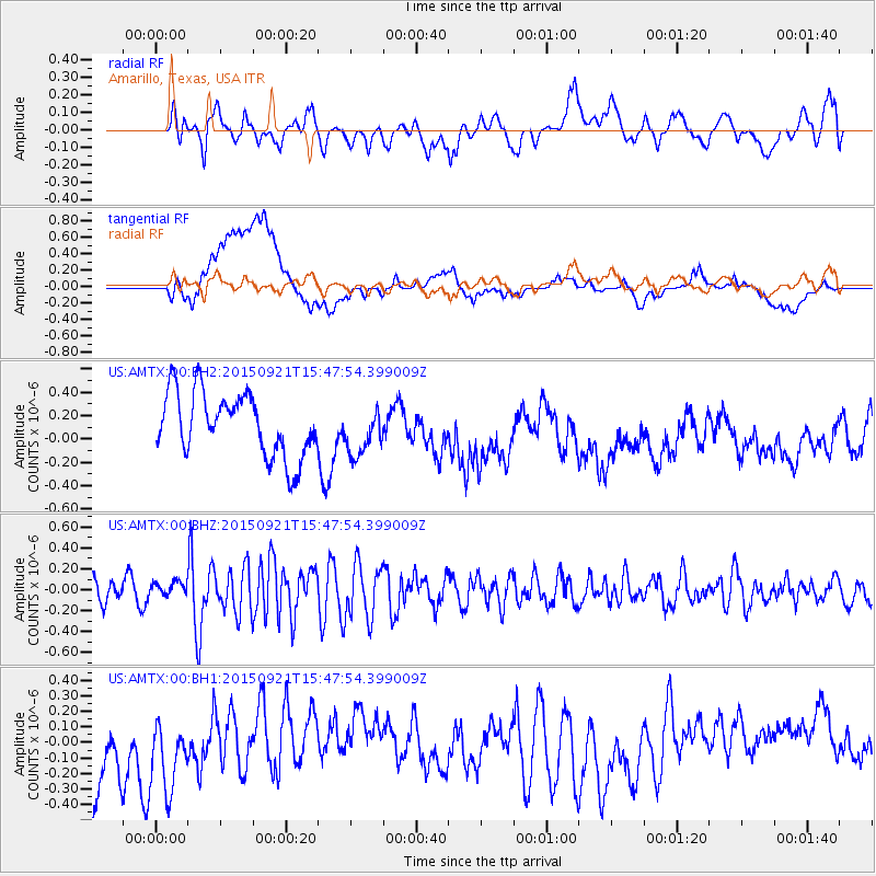
AMTX Amarillo, Texas, USA - Earthquake Result Viewer
*The percent match for this event was below the threshold and hence no stack was calculated.
| Earthquake location: |
Near Coast Of Central Chile |
| Earthquake latitude/longitude: |
-31.0/-71.8 |
| Earthquake time(UTC): |
2015/09/21 (264) 15:37:08 GMT |
| Earthquake Depth: |
26 km |
| Earthquake Magnitude: |
5.4 mww |
| Earthquake Catalog/Contributor: |
NEIC PDE/us |
|
| Network: |
US United States National Seismic Network |
| Station: |
AMTX Amarillo, Texas, USA |
| Lat/Lon: |
34.53 N/101.41 W |
| Elevation: |
1010 m |
|
| Distance: |
70.9 deg |
| Az: |
334.425 deg |
| Baz: |
153.328 deg |
| Ray Param: |
$rayparam |
*The percent match for this event was below the threshold and hence was not used in the summary stack. |
|
| Radial Match: |
42.10867 % |
| Radial Bump: |
400 |
| Transverse Match: |
46.392982 % |
| Transverse Bump: |
400 |
| SOD ConfigId: |
7422571 |
| Insert Time: |
2019-04-20 23:23:46.713 +0000 |
| GWidth: |
2.5 |
| Max Bumps: |
400 |
| Tol: |
0.001 |
|
Signal To Noise
| Channel | StoN | STA | LTA |
| US:AMTX:00:BHZ:20150921T15:47:54.399009Z | 0.41111803 | 7.244305E-8 | 1.7620985E-7 |
| US:AMTX:00:BH1:20150921T15:47:54.399009Z | 1.2339945 | 2.7072173E-7 | 2.1938648E-7 |
| US:AMTX:00:BH2:20150921T15:47:54.399009Z | 0.9817886 | 2.74454E-7 | 2.795449E-7 |
| Arrivals |
| Ps | |
| PpPs | |
| PsPs/PpSs | |


