You are here: Home > Network List > IU - Global Seismograph Network (GSN - IRIS/USGS) Stations List
> Station KMBO Kilima Mbogo, Kenya > Earthquake Result Viewer
KMBO Kilima Mbogo, Kenya - Earthquake Result Viewer
| Earthquake location: |
Savu Sea |
| Earthquake latitude/longitude: |
-9.4/122.8 |
| Earthquake time(UTC): |
2004/04/23 (114) 01:50:30 GMT |
| Earthquake Depth: |
66 km |
| Earthquake Magnitude: |
6.5 MB, 6.7 MW, 6.7 MW |
| Earthquake Catalog/Contributor: |
WHDF/NEIC |
|
| Network: |
IU Global Seismograph Network (GSN - IRIS/USGS) |
| Station: |
KMBO Kilima Mbogo, Kenya |
| Lat/Lon: |
1.13 S/37.25 E |
| Elevation: |
1960 m |
|
| Distance: |
85.5 deg |
| Az: |
269.607 deg |
| Baz: |
99.242 deg |
| Ray Param: |
0.04462087 |
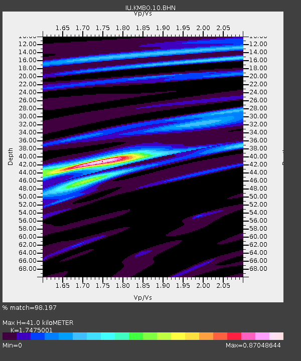
| Estimated Moho Depth: |
41.0 km |
| Estimated Crust Vp/Vs: |
1.75 |
| Assumed Crust Vp: |
6.601 km/s |
| Estimated Crust Vs: |
3.777 km/s |
| Estimated Crust Poisson's Ratio: |
0.26 |
|
| Radial Match: |
98.197 % |
| Radial Bump: |
342 |
| Transverse Match: |
92.91847 % |
| Transverse Bump: |
400 |
| SOD ConfigId: |
2459 |
| Insert Time: |
2010-03-04 20:23:29.329 +0000 |
| GWidth: |
2.5 |
| Max Bumps: |
400 |
| Tol: |
0.001 |
|
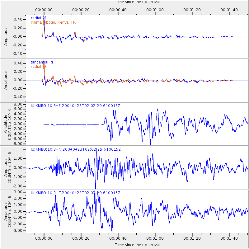
Signal To Noise
| Channel | StoN | STA | LTA |
| IU:KMBO:10:BHN:20040423T02:02:29.610015Z | 2.7124624 | 1.6346351E-7 | 6.026388E-8 |
| IU:KMBO:10:BHE:20040423T02:02:29.610015Z | 5.2511854 | 4.557262E-7 | 8.678539E-8 |
| IU:KMBO:10:BHZ:20040423T02:02:29.610015Z | 12.641665 | 1.193519E-6 | 9.441153E-8 |
| Arrivals |
| Ps | 4.8 SECOND |
| PpPs | 17 SECOND |
| PsPs/PpSs | 21 SECOND |


