You are here: Home > Network List > GS - US Geological Survey Networks Stations List
> Station OK031 2598 S. Brethren Rd., Cushing, OK, USA > Earthquake Result Viewer
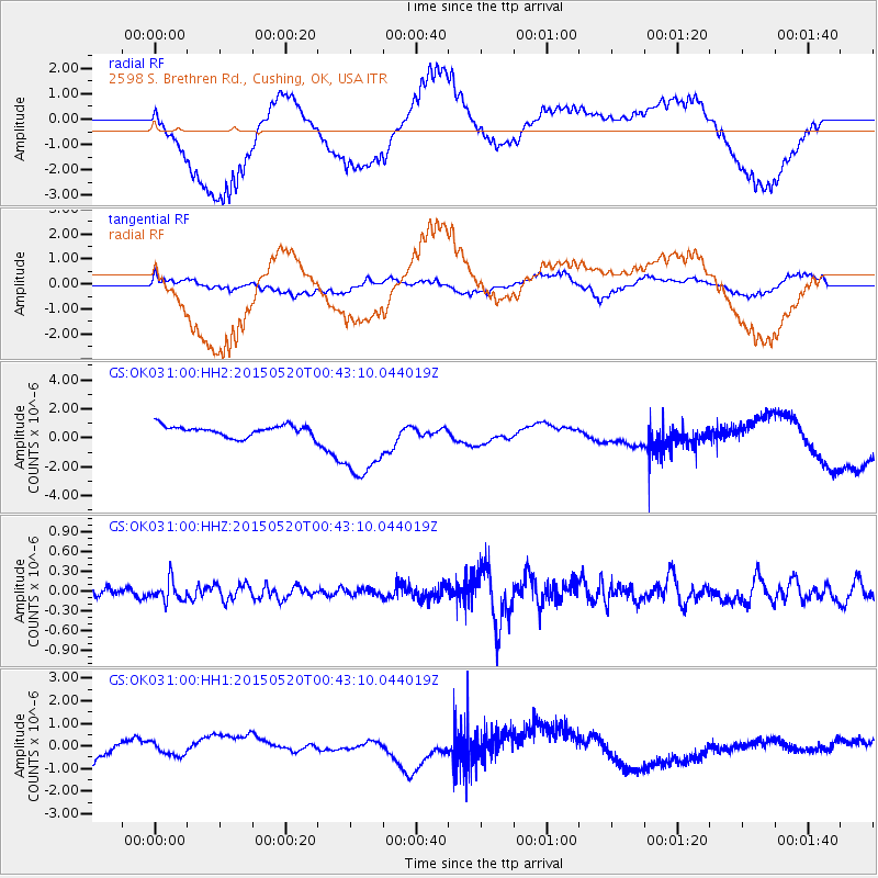
OK031 2598 S. Brethren Rd., Cushing, OK, USA - Earthquake Result Viewer
*The percent match for this event was below the threshold and hence no stack was calculated.
| Earthquake location: |
Tonga Islands |
| Earthquake latitude/longitude: |
-19.3/-175.5 |
| Earthquake time(UTC): |
2015/05/20 (140) 00:30:51 GMT |
| Earthquake Depth: |
180 km |
| Earthquake Magnitude: |
6.0 MWP |
| Earthquake Catalog/Contributor: |
NEIC PDE/NEIC COMCAT |
|
| Network: |
GS US Geological Survey Networks |
| Station: |
OK031 2598 S. Brethren Rd., Cushing, OK, USA |
| Lat/Lon: |
35.95 N/96.84 W |
| Elevation: |
290 m |
|
| Distance: |
92.3 deg |
| Az: |
52.758 deg |
| Baz: |
247.924 deg |
| Ray Param: |
$rayparam |
*The percent match for this event was below the threshold and hence was not used in the summary stack. |
|
| Radial Match: |
54.849663 % |
| Radial Bump: |
400 |
| Transverse Match: |
20.71692 % |
| Transverse Bump: |
400 |
| SOD ConfigId: |
976571 |
| Insert Time: |
2015-06-03 00:35:17.745 +0000 |
| GWidth: |
2.5 |
| Max Bumps: |
400 |
| Tol: |
0.001 |
|
Signal To Noise
| Channel | StoN | STA | LTA |
| GS:OK031:00:HHZ:20150520T00:43:10.044019Z | 2.0125701 | 1.5453328E-7 | 7.678404E-8 |
| GS:OK031:00:HH1:20150520T00:43:10.044019Z | 0.49916932 | 2.9297345E-7 | 5.8692194E-7 |
| GS:OK031:00:HH2:20150520T00:43:10.044019Z | 7.3108993 | 2.6592563E-6 | 3.637386E-7 |
| Arrivals |
| Ps | |
| PpPs | |
| PsPs/PpSs | |


