You are here: Home > Network List > 7A - Mid-Atlantic Geophysical Integrative Collaboration Stations List
> Station JSPR Franklin, West Virginia USA > Earthquake Result Viewer
JSPR Franklin, West Virginia USA - Earthquake Result Viewer
| Earthquake location: |
Near Coast Of Central Chile |
| Earthquake latitude/longitude: |
-31.7/-71.6 |
| Earthquake time(UTC): |
2015/09/21 (264) 17:39:58 GMT |
| Earthquake Depth: |
25 km |
| Earthquake Magnitude: |
6.5 MB, 6.5 MI, 6.6 MWW |
| Earthquake Catalog/Contributor: |
NEIC PDE/NEIC COMCAT |
|
| Network: |
7A Mid-Atlantic Geophysical Integrative Collaboration |
| Station: |
JSPR Franklin, West Virginia USA |
| Lat/Lon: |
38.64 N/79.33 W |
| Elevation: |
527 m |
|
| Distance: |
70.4 deg |
| Az: |
353.606 deg |
| Baz: |
173.042 deg |
| Ray Param: |
0.05498642 |
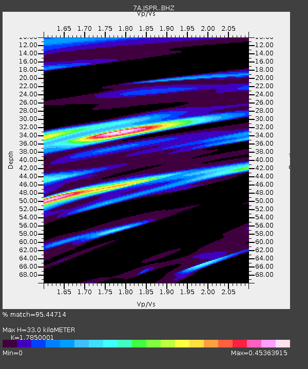
| Estimated Moho Depth: |
33.0 km |
| Estimated Crust Vp/Vs: |
1.79 |
| Assumed Crust Vp: |
6.159 km/s |
| Estimated Crust Vs: |
3.45 km/s |
| Estimated Crust Poisson's Ratio: |
0.27 |
|
| Radial Match: |
95.44714 % |
| Radial Bump: |
366 |
| Transverse Match: |
87.87996 % |
| Transverse Bump: |
400 |
| SOD ConfigId: |
7422571 |
| Insert Time: |
2019-04-20 23:26:34.266 +0000 |
| GWidth: |
2.5 |
| Max Bumps: |
400 |
| Tol: |
0.001 |
|

Signal To Noise
| Channel | StoN | STA | LTA |
| 7A:JSPR: :BHZ:20150921T17:50:39.640024Z | 25.161573 | 5.3704316E-6 | 2.1343783E-7 |
| 7A:JSPR: :BHN:20150921T17:50:39.640024Z | 14.83938 | 2.3510077E-6 | 1.5843032E-7 |
| 7A:JSPR: :BHE:20150921T17:50:39.640024Z | 2.3373275 | 2.945667E-7 | 1.2602713E-7 |
| Arrivals |
| Ps | 4.3 SECOND |
| PpPs | 14 SECOND |
| PsPs/PpSs | 19 SECOND |


