You are here: Home > Network List > 7A - Mid-Atlantic Geophysical Integrative Collaboration Stations List
> Station LBDL Montpelier, Virginia USA > Earthquake Result Viewer
LBDL Montpelier, Virginia USA - Earthquake Result Viewer
| Earthquake location: |
Near Coast Of Central Chile |
| Earthquake latitude/longitude: |
-31.7/-71.6 |
| Earthquake time(UTC): |
2015/09/21 (264) 17:39:58 GMT |
| Earthquake Depth: |
25 km |
| Earthquake Magnitude: |
6.5 MB, 6.5 MI, 6.6 MWW |
| Earthquake Catalog/Contributor: |
NEIC PDE/NEIC COMCAT |
|
| Network: |
7A Mid-Atlantic Geophysical Integrative Collaboration |
| Station: |
LBDL Montpelier, Virginia USA |
| Lat/Lon: |
37.80 N/77.64 W |
| Elevation: |
48 m |
|
| Distance: |
69.4 deg |
| Az: |
354.922 deg |
| Baz: |
174.537 deg |
| Ray Param: |
0.055633858 |
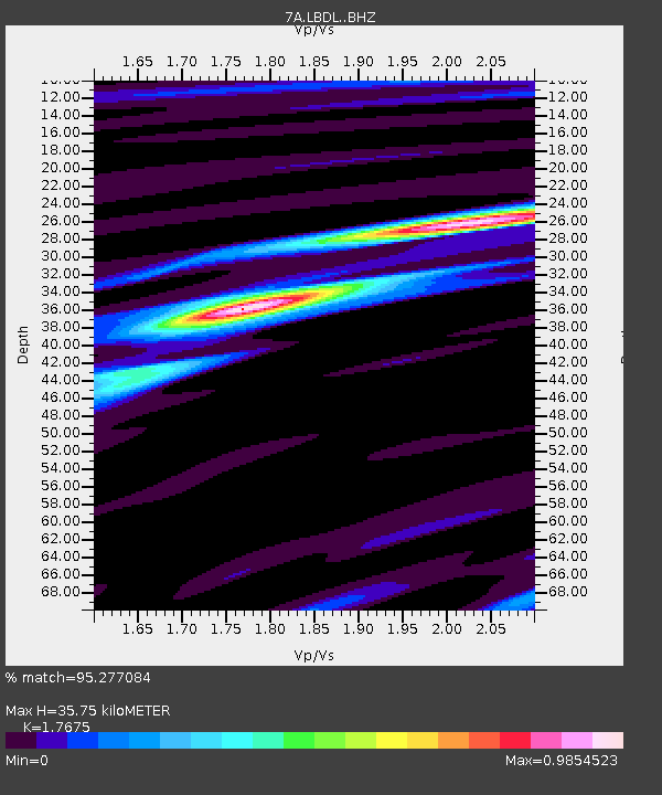
| Estimated Moho Depth: |
35.75 km |
| Estimated Crust Vp/Vs: |
1.77 |
| Assumed Crust Vp: |
6.565 km/s |
| Estimated Crust Vs: |
3.714 km/s |
| Estimated Crust Poisson's Ratio: |
0.26 |
|
| Radial Match: |
95.277084 % |
| Radial Bump: |
266 |
| Transverse Match: |
92.1706 % |
| Transverse Bump: |
400 |
| SOD ConfigId: |
7422571 |
| Insert Time: |
2019-04-20 23:26:34.822 +0000 |
| GWidth: |
2.5 |
| Max Bumps: |
400 |
| Tol: |
0.001 |
|

Signal To Noise
| Channel | StoN | STA | LTA |
| 7A:LBDL: :BHZ:20150921T17:50:33.640024Z | 30.035667 | 6.4558863E-6 | 2.1494067E-7 |
| 7A:LBDL: :BHN:20150921T17:50:33.640024Z | 13.346589 | 3.0283556E-6 | 2.269011E-7 |
| 7A:LBDL: :BHE:20150921T17:50:33.640024Z | 1.8889668 | 3.2895693E-7 | 1.7414648E-7 |
| Arrivals |
| Ps | 4.3 SECOND |
| PpPs | 14 SECOND |
| PsPs/PpSs | 19 SECOND |


