You are here: Home > Network List > 7A - Mid-Atlantic Geophysical Integrative Collaboration Stations List
> Station NAZF Center Point, West Virginia USA > Earthquake Result Viewer
NAZF Center Point, West Virginia USA - Earthquake Result Viewer
| Earthquake location: |
Near Coast Of Central Chile |
| Earthquake latitude/longitude: |
-31.7/-71.6 |
| Earthquake time(UTC): |
2015/09/21 (264) 17:39:58 GMT |
| Earthquake Depth: |
25 km |
| Earthquake Magnitude: |
6.5 MB, 6.5 MI, 6.6 MWW |
| Earthquake Catalog/Contributor: |
NEIC PDE/NEIC COMCAT |
|
| Network: |
7A Mid-Atlantic Geophysical Integrative Collaboration |
| Station: |
NAZF Center Point, West Virginia USA |
| Lat/Lon: |
39.38 N/80.64 W |
| Elevation: |
0.0 m |
|
| Distance: |
71.3 deg |
| Az: |
352.64 deg |
| Baz: |
171.905 deg |
| Ray Param: |
0.054419573 |
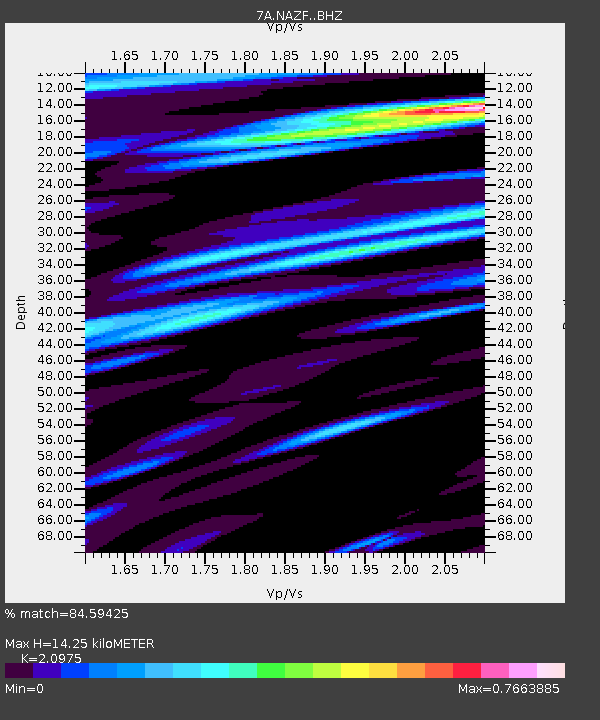
| Estimated Moho Depth: |
14.25 km |
| Estimated Crust Vp/Vs: |
2.10 |
| Assumed Crust Vp: |
6.207 km/s |
| Estimated Crust Vs: |
2.959 km/s |
| Estimated Crust Poisson's Ratio: |
0.35 |
|
| Radial Match: |
84.59425 % |
| Radial Bump: |
400 |
| Transverse Match: |
80.59467 % |
| Transverse Bump: |
400 |
| SOD ConfigId: |
7422571 |
| Insert Time: |
2019-04-20 23:26:38.554 +0000 |
| GWidth: |
2.5 |
| Max Bumps: |
400 |
| Tol: |
0.001 |
|

Signal To Noise
| Channel | StoN | STA | LTA |
| 7A:NAZF: :BHZ:20150921T17:50:44.940012Z | 12.29838 | 5.0363747E-6 | 4.0951528E-7 |
| 7A:NAZF: :BHN:20150921T17:50:44.940012Z | 5.3927655 | 1.3142222E-6 | 2.4370098E-7 |
| 7A:NAZF: :BHE:20150921T17:50:44.940012Z | 1.6162338 | 2.8740396E-7 | 1.7782327E-7 |
| Arrivals |
| Ps | 2.6 SECOND |
| PpPs | 6.9 SECOND |
| PsPs/PpSs | 9.5 SECOND |


