You are here: Home > Network List > 7A - Mid-Atlantic Geophysical Integrative Collaboration Stations List
> Station PETO Lost Creek, West Virginia USA > Earthquake Result Viewer
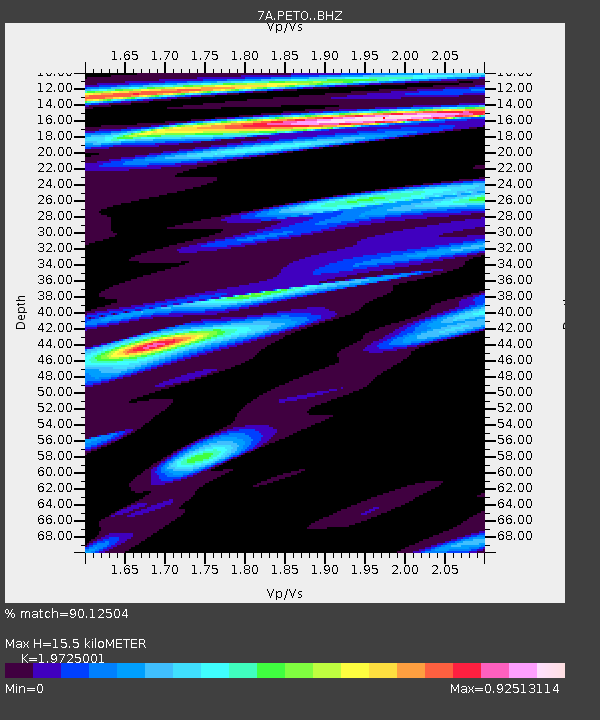
PETO Lost Creek, West Virginia USA - Earthquake Result Viewer
| Earthquake location: |
Near Coast Of Central Chile |
| Earthquake latitude/longitude: |
-31.7/-71.6 |
| Earthquake time(UTC): |
2015/09/21 (264) 17:39:58 GMT |
| Earthquake Depth: |
25 km |
| Earthquake Magnitude: |
6.5 MB, 6.5 MI, 6.6 MWW |
| Earthquake Catalog/Contributor: |
NEIC PDE/NEIC COMCAT |
|
| Network: |
7A Mid-Atlantic Geophysical Integrative Collaboration |
| Station: |
PETO Lost Creek, West Virginia USA |
| Lat/Lon: |
39.16 N/80.33 W |
| Elevation: |
0.0 m |
|
| Distance: |
71.0 deg |
| Az: |
352.86 deg |
| Baz: |
172.171 deg |
| Ray Param: |
0.054576743 |
| Estimated Moho Depth: |
15.5 km |
| Estimated Crust Vp/Vs: |
1.97 |
| Assumed Crust Vp: |
6.207 km/s |
| Estimated Crust Vs: |
3.147 km/s |
| Estimated Crust Poisson's Ratio: |
0.33 |
|
| Radial Match: |
90.12504 % |
| Radial Bump: |
400 |
| Transverse Match: |
73.847946 % |
| Transverse Bump: |
400 |
| SOD ConfigId: |
7422571 |
| Insert Time: |
2019-04-20 23:26:39.130 +0000 |
| GWidth: |
2.5 |
| Max Bumps: |
400 |
| Tol: |
0.001 |
|

Signal To Noise
| Channel | StoN | STA | LTA |
| 7A:PETO: :BHZ:20150921T17:50:43.414988Z | 14.16263 | 4.694455E-6 | 3.3146776E-7 |
| 7A:PETO: :BHN:20150921T17:50:43.414988Z | 5.6576824 | 1.676927E-6 | 2.963982E-7 |
| 7A:PETO: :BHE:20150921T17:50:43.414988Z | 1.8171129 | 4.3291507E-7 | 2.3824335E-7 |
| Arrivals |
| Ps | 2.5 SECOND |
| PpPs | 7.2 SECOND |
| PsPs/PpSs | 9.7 SECOND |


