You are here: Home > Network List > 7A - Mid-Atlantic Geophysical Integrative Collaboration Stations List
> Station PVGR Lower Salem, Ohio USA > Earthquake Result Viewer
PVGR Lower Salem, Ohio USA - Earthquake Result Viewer
| Earthquake location: |
Near Coast Of Central Chile |
| Earthquake latitude/longitude: |
-31.7/-71.6 |
| Earthquake time(UTC): |
2015/09/21 (264) 17:39:58 GMT |
| Earthquake Depth: |
25 km |
| Earthquake Magnitude: |
6.5 MB, 6.5 MI, 6.6 MWW |
| Earthquake Catalog/Contributor: |
NEIC PDE/NEIC COMCAT |
|
| Network: |
7A Mid-Atlantic Geophysical Integrative Collaboration |
| Station: |
PVGR Lower Salem, Ohio USA |
| Lat/Lon: |
39.57 N/81.38 W |
| Elevation: |
0.0 m |
|
| Distance: |
71.5 deg |
| Az: |
352.07 deg |
| Baz: |
171.253 deg |
| Ray Param: |
0.05423712 |
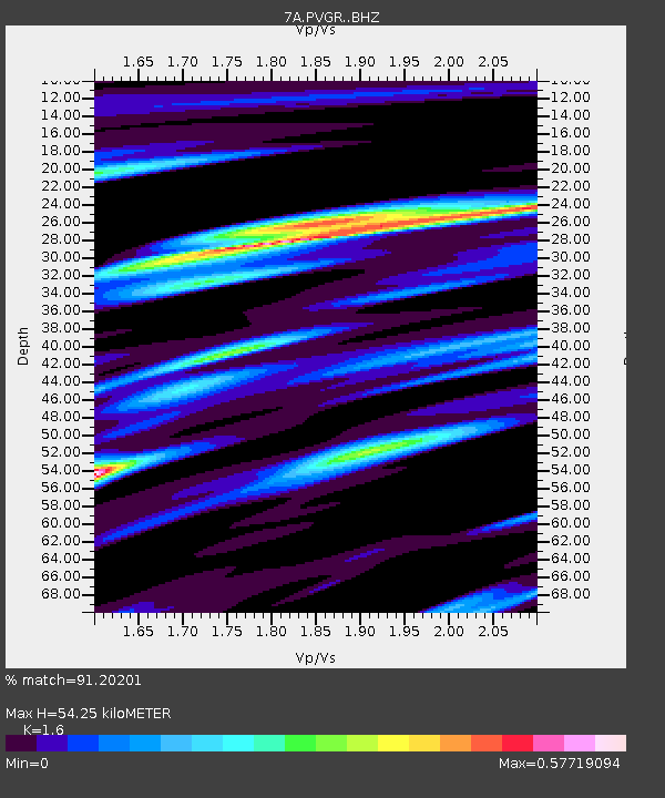
| Estimated Moho Depth: |
54.25 km |
| Estimated Crust Vp/Vs: |
1.60 |
| Assumed Crust Vp: |
6.207 km/s |
| Estimated Crust Vs: |
3.879 km/s |
| Estimated Crust Poisson's Ratio: |
0.18 |
|
| Radial Match: |
91.20201 % |
| Radial Bump: |
400 |
| Transverse Match: |
79.36163 % |
| Transverse Bump: |
400 |
| SOD ConfigId: |
7422571 |
| Insert Time: |
2019-04-20 23:26:39.559 +0000 |
| GWidth: |
2.5 |
| Max Bumps: |
400 |
| Tol: |
0.001 |
|

Signal To Noise
| Channel | StoN | STA | LTA |
| 7A:PVGR: :BHZ:20150921T17:50:46.589976Z | 17.782991 | 5.2672817E-6 | 2.9619773E-7 |
| 7A:PVGR: :BHN:20150921T17:50:46.589976Z | 16.845764 | 2.0897764E-6 | 1.2405353E-7 |
| 7A:PVGR: :BHE:20150921T17:50:46.589976Z | 1.1561556 | 2.3831099E-7 | 2.0612362E-7 |
| Arrivals |
| Ps | 5.4 SECOND |
| PpPs | 22 SECOND |
| PsPs/PpSs | 27 SECOND |


