You are here: Home > Network List > IU - Global Seismograph Network (GSN - IRIS/USGS) Stations List
> Station KMBO Kilima Mbogo, Kenya > Earthquake Result Viewer
KMBO Kilima Mbogo, Kenya - Earthquake Result Viewer
| Earthquake location: |
Northern Molucca Sea |
| Earthquake latitude/longitude: |
2.7/126.4 |
| Earthquake time(UTC): |
2005/03/04 (063) 19:05:19 GMT |
| Earthquake Depth: |
59 km |
| Earthquake Magnitude: |
6.1 MB, 5.9 MW, 5.8 MW |
| Earthquake Catalog/Contributor: |
WHDF/NEIC |
|
| Network: |
IU Global Seismograph Network (GSN - IRIS/USGS) |
| Station: |
KMBO Kilima Mbogo, Kenya |
| Lat/Lon: |
1.13 S/37.25 E |
| Elevation: |
1960 m |
|
| Distance: |
89.2 deg |
| Az: |
268.843 deg |
| Baz: |
87.332 deg |
| Ray Param: |
0.041915998 |
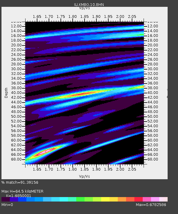
| Estimated Moho Depth: |
64.5 km |
| Estimated Crust Vp/Vs: |
1.69 |
| Assumed Crust Vp: |
6.601 km/s |
| Estimated Crust Vs: |
3.917 km/s |
| Estimated Crust Poisson's Ratio: |
0.23 |
|
| Radial Match: |
91.39156 % |
| Radial Bump: |
400 |
| Transverse Match: |
62.813805 % |
| Transverse Bump: |
400 |
| SOD ConfigId: |
2455 |
| Insert Time: |
2010-03-04 20:24:11.463 +0000 |
| GWidth: |
2.5 |
| Max Bumps: |
400 |
| Tol: |
0.001 |
|

Signal To Noise
| Channel | StoN | STA | LTA |
| IU:KMBO:10:BHN:20050304T19:17:38.04802Z | 1.5066143 | 1.130998E-7 | 7.506885E-8 |
| IU:KMBO:10:BHE:20050304T19:17:38.04802Z | 5.5798707 | 1.9050428E-7 | 3.4141344E-8 |
| IU:KMBO:10:BHZ:20050304T19:17:38.04802Z | 9.067919 | 5.808332E-7 | 6.4053644E-8 |
| Arrivals |
| Ps | 6.9 SECOND |
| PpPs | 26 SECOND |
| PsPs/PpSs | 32 SECOND |


