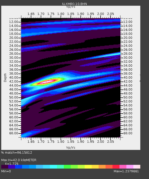
KMBO Kilima Mbogo, Kenya - Earthquake Result Viewer

Earthquake location: Off W Coast Of Northern Sumatra
Earthquake latitude/longitude: 3.0/95.4
Earthquake time(UTC): 2005/03/30 (089) 16:19:41 GMT
Earthquake Depth: 22 km
Earthquake Magnitude: 5.9 MB, 6.2 MS, 6.4 MW, 6.3 MW
Earthquake Catalog/Contributor: WHDF/NEIC
Network: IU Global Seismograph Network (GSN - IRIS/USGS)
Station: KMBO Kilima Mbogo, Kenya
Lat/Lon: 1.13 S/37.25 E
Elevation: 1960 m
Distance: 58.3 deg
Az: 266.842 deg
Baz: 85.811 deg
Ray Param: 0.062916055
Estimated Moho Depth: 42.0 km
Estimated Crust Vp/Vs: 1.73
Assumed Crust Vp: 6.601 km/s
Estimated Crust Vs: 3.826 km/s
Estimated Crust Poisson's Ratio: 0.25
Radial Match: 96.15812 %
Radial Bump: 281
Transverse Match: 78.95091 %
Transverse Bump: 400
SOD ConfigId: 2459
Insert Time: 2010-03-04 20:24:20.237 +0000
GWidth: 2.5
Max Bumps: 400
Tol: 0.001

Signal To Noise

ChannelStoNSTALTA
IU:KMBO:10:BHN:20050330T16:29:03.047021Z1.73424521.2440118E-77.173218E-8
IU:KMBO:10:BHE:20050330T16:29:03.047021Z5.79989773.6684574E-76.325038E-8
IU:KMBO:10:BHZ:20050330T16:29:03.047021Z8.8972885.6737036E-76.376891E-8
Arrivals
Ps4.9 SECOND
PpPs16 SECOND
PsPs/PpSs21 SECOND