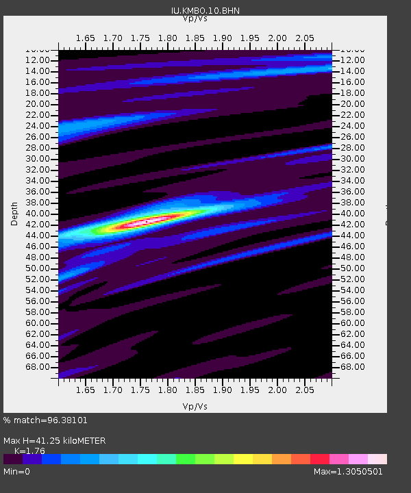
KMBO Kilima Mbogo, Kenya - Earthquake Result Viewer

Earthquake location: Northern Sumatra, Indonesia
Earthquake latitude/longitude: 2.0/97.9
Earthquake time(UTC): 2005/04/03 (093) 03:10:56 GMT
Earthquake Depth: 36 km
Earthquake Magnitude: 6.0 MB, 5.9 MS, 6.3 MW, 6.3 MW
Earthquake Catalog/Contributor: WHDF/NEIC
Network: IU Global Seismograph Network (GSN - IRIS/USGS)
Station: KMBO Kilima Mbogo, Kenya
Lat/Lon: 1.13 S/37.25 E
Elevation: 1960 m
Distance: 60.8 deg
Az: 267.591 deg
Baz: 87.07 deg
Ray Param: 0.06125397
Estimated Moho Depth: 41.25 km
Estimated Crust Vp/Vs: 1.76
Assumed Crust Vp: 6.601 km/s
Estimated Crust Vs: 3.75 km/s
Estimated Crust Poisson's Ratio: 0.26
Radial Match: 96.38101 %
Radial Bump: 245
Transverse Match: 81.09324 %
Transverse Bump: 400
SOD ConfigId: 2459
Insert Time: 2010-03-04 20:24:24.652 +0000
GWidth: 2.5
Max Bumps: 400
Tol: 0.001

Signal To Noise

ChannelStoNSTALTA
IU:KMBO:10:BHN:20050403T03:20:33.897002Z0.78304693.7676333E-84.811504E-8
IU:KMBO:10:BHE:20050403T03:20:33.897002Z1.79554369.492228E-85.286548E-8
IU:KMBO:10:BHZ:20050403T03:20:33.897002Z2.43305182.1737203E-78.9341306E-8
Arrivals
Ps5.0 SECOND
PpPs16 SECOND
PsPs/PpSs21 SECOND