You are here: Home > Network List > IU - Global Seismograph Network (GSN - IRIS/USGS) Stations List
> Station KMBO Kilima Mbogo, Kenya > Earthquake Result Viewer
KMBO Kilima Mbogo, Kenya - Earthquake Result Viewer
| Earthquake location: |
Xizang |
| Earthquake latitude/longitude: |
30.5/83.7 |
| Earthquake time(UTC): |
2005/04/07 (097) 20:04:41 GMT |
| Earthquake Depth: |
11 km |
| Earthquake Magnitude: |
6.0 MB, 6.1 MS, 6.3 MW, 6.2 MW |
| Earthquake Catalog/Contributor: |
WHDF/NEIC |
|
| Network: |
IU Global Seismograph Network (GSN - IRIS/USGS) |
| Station: |
KMBO Kilima Mbogo, Kenya |
| Lat/Lon: |
1.13 S/37.25 E |
| Elevation: |
1960 m |
|
| Distance: |
54.2 deg |
| Az: |
243.256 deg |
| Baz: |
50.444 deg |
| Ray Param: |
0.06560461 |
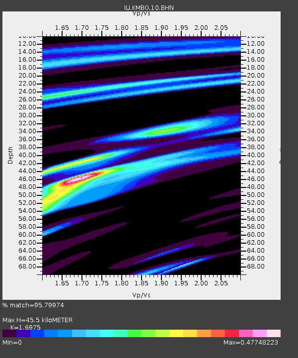
| Estimated Moho Depth: |
45.5 km |
| Estimated Crust Vp/Vs: |
1.70 |
| Assumed Crust Vp: |
6.601 km/s |
| Estimated Crust Vs: |
3.888 km/s |
| Estimated Crust Poisson's Ratio: |
0.23 |
|
| Radial Match: |
95.79974 % |
| Radial Bump: |
270 |
| Transverse Match: |
84.89985 % |
| Transverse Bump: |
400 |
| SOD ConfigId: |
2459 |
| Insert Time: |
2010-03-04 20:24:28.884 +0000 |
| GWidth: |
2.5 |
| Max Bumps: |
400 |
| Tol: |
0.001 |
|

Signal To Noise
| Channel | StoN | STA | LTA |
| IU:KMBO:10:BHN:20050407T20:13:35.348025Z | 6.6392903 | 6.164422E-7 | 9.284761E-8 |
| IU:KMBO:10:BHE:20050407T20:13:35.348025Z | 4.02741 | 6.971594E-7 | 1.7310366E-7 |
| IU:KMBO:10:BHZ:20050407T20:13:35.348025Z | 15.5625105 | 1.5876005E-6 | 1.02014425E-7 |
| Arrivals |
| Ps | 5.1 SECOND |
| PpPs | 18 SECOND |
| PsPs/PpSs | 23 SECOND |


