You are here: Home > Network List > CI - Caltech Regional Seismic Network Stations List
> Station BAR Barrett, Tecate, CA, USA > Earthquake Result Viewer
BAR Barrett, Tecate, CA, USA - Earthquake Result Viewer
| Earthquake location: |
Near Coast Of Central Chile |
| Earthquake latitude/longitude: |
-31.7/-71.6 |
| Earthquake time(UTC): |
2015/09/21 (264) 17:39:58 GMT |
| Earthquake Depth: |
25 km |
| Earthquake Magnitude: |
6.5 MB, 6.5 MI, 6.6 MWW |
| Earthquake Catalog/Contributor: |
NEIC PDE/NEIC COMCAT |
|
| Network: |
CI Caltech Regional Seismic Network |
| Station: |
BAR Barrett, Tecate, CA, USA |
| Lat/Lon: |
32.68 N/116.67 W |
| Elevation: |
521 m |
|
| Distance: |
76.9 deg |
| Az: |
322.22 deg |
| Baz: |
141.763 deg |
| Ray Param: |
0.050645337 |
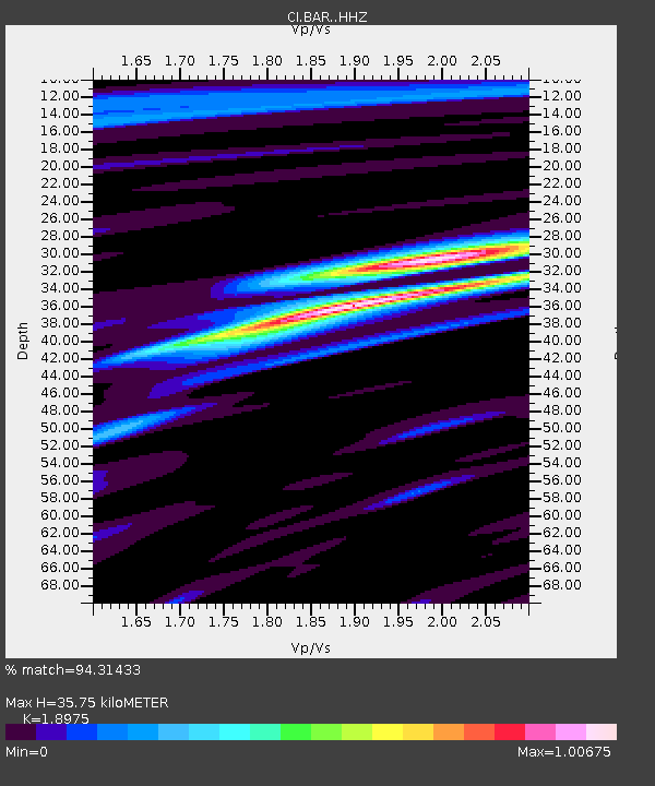
| Estimated Moho Depth: |
35.75 km |
| Estimated Crust Vp/Vs: |
1.90 |
| Assumed Crust Vp: |
6.264 km/s |
| Estimated Crust Vs: |
3.301 km/s |
| Estimated Crust Poisson's Ratio: |
0.31 |
|
| Radial Match: |
94.31433 % |
| Radial Bump: |
321 |
| Transverse Match: |
87.25824 % |
| Transverse Bump: |
400 |
| SOD ConfigId: |
7422571 |
| Insert Time: |
2019-04-20 23:27:38.453 +0000 |
| GWidth: |
2.5 |
| Max Bumps: |
400 |
| Tol: |
0.001 |
|
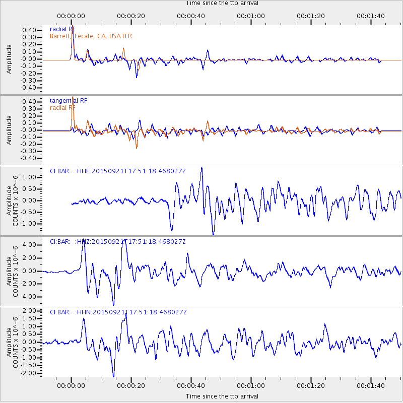
Signal To Noise
| Channel | StoN | STA | LTA |
| CI:BAR: :HHZ:20150921T17:51:18.468027Z | 27.021446 | 1.9930333E-6 | 7.375746E-8 |
| CI:BAR: :HHN:20150921T17:51:18.468027Z | 8.015311 | 6.263073E-7 | 7.813886E-8 |
| CI:BAR: :HHE:20150921T17:51:18.468027Z | 6.548728 | 5.2049234E-7 | 7.947992E-8 |
| Arrivals |
| Ps | 5.3 SECOND |
| PpPs | 16 SECOND |
| PsPs/PpSs | 21 SECOND |


