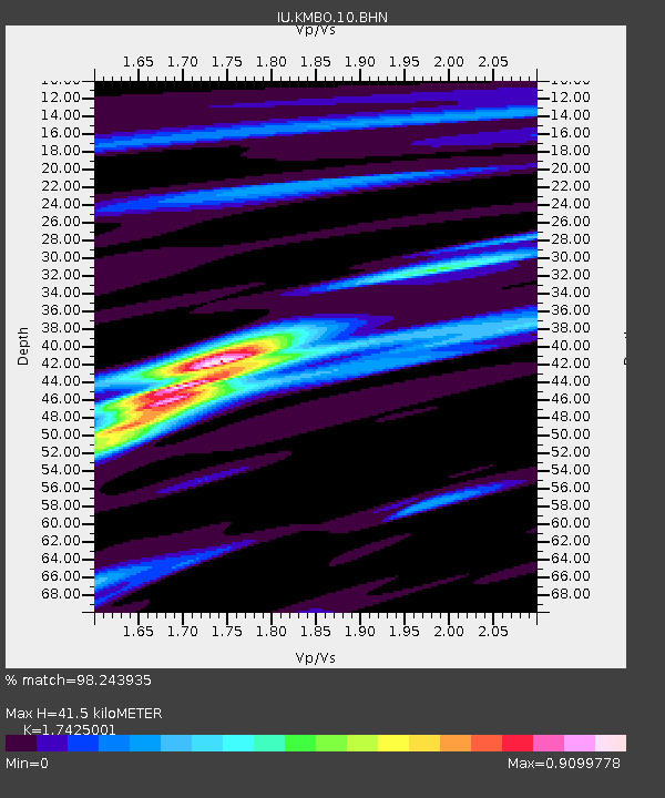
KMBO Kilima Mbogo, Kenya - Earthquake Result Viewer

Earthquake location: Southwest Of Sumatra, Indonesia
Earthquake latitude/longitude: -6.2/103.1
Earthquake time(UTC): 2005/05/10 (130) 01:09:05 GMT
Earthquake Depth: 17 km
Earthquake Magnitude: 5.9 MB, 6.4 MS, 6.2 MW, 6.2 MW
Earthquake Catalog/Contributor: WHDF/NEIC
Network: IU Global Seismograph Network (GSN - IRIS/USGS)
Station: KMBO Kilima Mbogo, Kenya
Lat/Lon: 1.13 S/37.25 E
Elevation: 1960 m
Distance: 65.9 deg
Az: 271.543 deg
Baz: 96.275 deg
Ray Param: 0.0579479
Estimated Moho Depth: 41.5 km
Estimated Crust Vp/Vs: 1.74
Assumed Crust Vp: 6.601 km/s
Estimated Crust Vs: 3.788 km/s
Estimated Crust Poisson's Ratio: 0.25
Radial Match: 98.243935 %
Radial Bump: 304
Transverse Match: 82.16628 %
Transverse Bump: 400
SOD ConfigId: 2455
Insert Time: 2010-03-04 20:24:46.986 +0000
GWidth: 2.5
Max Bumps: 400
Tol: 0.001

Signal To Noise

ChannelStoNSTALTA
IU:KMBO:10:BHN:20050510T01:19:18.782007Z0.63226046.215228E-89.830172E-8
IU:KMBO:10:BHE:20050510T01:19:18.782007Z9.6793385.316821E-75.492959E-8
IU:KMBO:10:BHZ:20050510T01:19:18.782007Z15.700871.1140967E-67.095764E-8
Arrivals
Ps4.9 SECOND
PpPs16 SECOND
PsPs/PpSs21 SECOND