You are here: Home > Network List > IU - Global Seismograph Network (GSN - IRIS/USGS) Stations List
> Station KMBO Kilima Mbogo, Kenya > Earthquake Result Viewer
KMBO Kilima Mbogo, Kenya - Earthquake Result Viewer

| Earthquake location: |
Egypt |
| Earthquake latitude/longitude: |
28.8/34.9 |
| Earthquake time(UTC): |
1995/11/22 (326) 04:15:11 GMT |
| Earthquake Depth: |
10 km |
| Earthquake Magnitude: |
6.2 MB, 7.3 MS, 7.2 UNKNOWN, 6.2 ML |
| Earthquake Catalog/Contributor: |
WHDF/NEIC |
|
| Network: |
IU Global Seismograph Network (GSN - IRIS/USGS) |
| Station: |
KMBO Kilima Mbogo, Kenya |
| Lat/Lon: |
1.13 S/37.25 E |
| Elevation: |
1960 m |
|
| Distance: |
29.9 deg |
| Az: |
175.194 deg |
| Baz: |
355.783 deg |
| Ray Param: |
0.079483114 |
| Estimated Moho Depth: |
45.75 km |
| Estimated Crust Vp/Vs: |
1.60 |
| Assumed Crust Vp: |
6.601 km/s |
| Estimated Crust Vs: |
4.125 km/s |
| Estimated Crust Poisson's Ratio: |
0.18 |
|
| Radial Match: |
92.73782 % |
| Radial Bump: |
250 |
| Transverse Match: |
81.91784 % |
| Transverse Bump: |
400 |
| SOD ConfigId: |
6273 |
| Insert Time: |
2010-03-04 20:24:59.794 +0000 |
| GWidth: |
2.5 |
| Max Bumps: |
400 |
| Tol: |
0.001 |
|
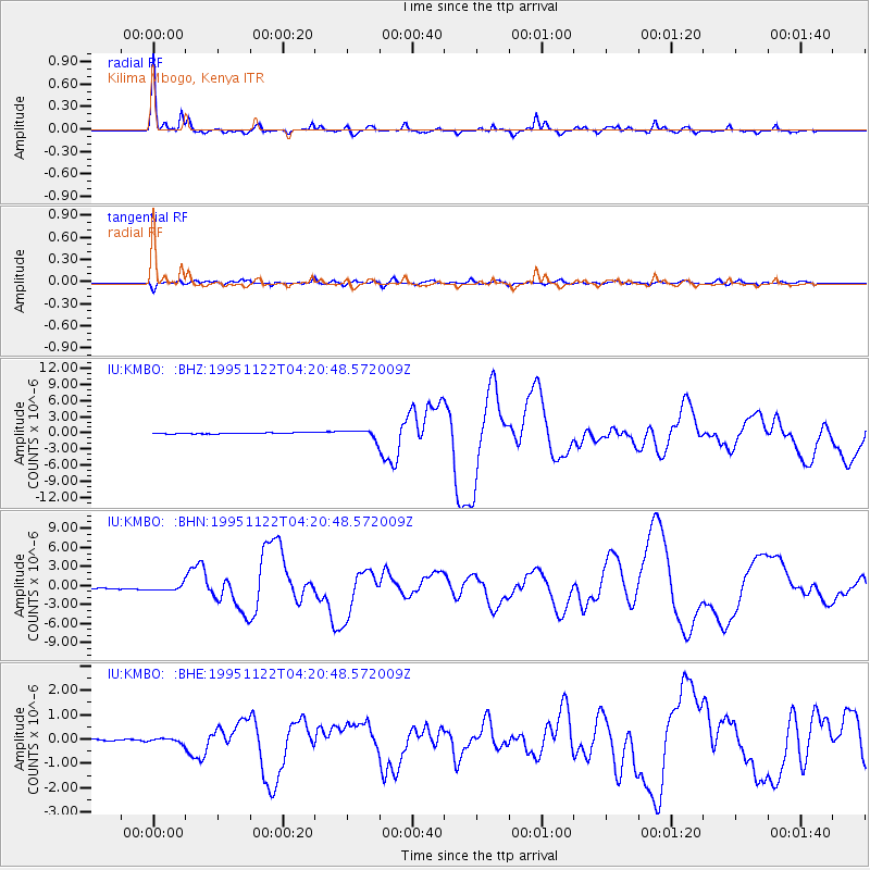
Signal To Noise
| Channel | StoN | STA | LTA |
| IU:KMBO: :BHN:19951122T04:20:48.572009Z | 5.8001084 | 4.4605855E-7 | 7.69052E-8 |
| IU:KMBO: :BHE:19951122T04:20:48.572009Z | 1.7283616 | 9.550769E-8 | 5.525909E-8 |
| IU:KMBO: :BHZ:19951122T04:20:48.572009Z | 8.207963 | 7.995972E-7 | 9.741726E-8 |
| Arrivals |
| Ps | 4.6 SECOND |
| PpPs | 16 SECOND |
| PsPs/PpSs | 21 SECOND |


