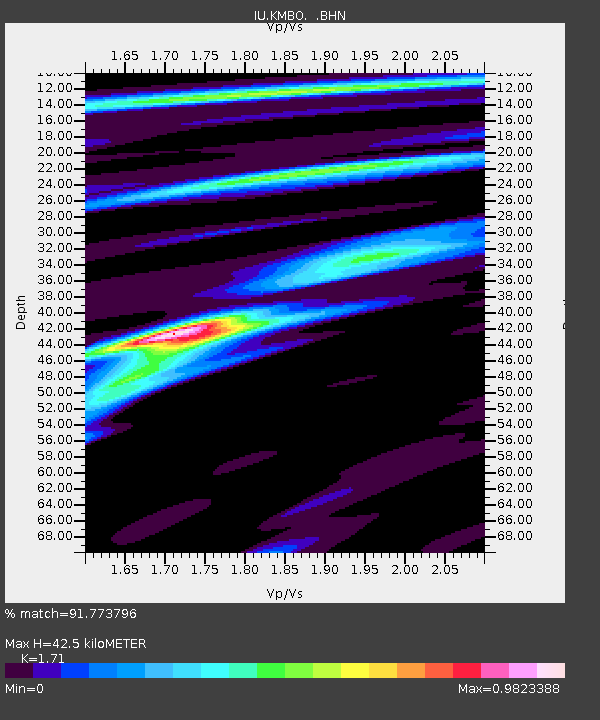
KMBO Kilima Mbogo, Kenya - Earthquake Result Viewer

Earthquake location: Hindu Kush Region, Afghanistan
Earthquake latitude/longitude: 36.4/70.4
Earthquake time(UTC): 1995/10/18 (291) 09:30:38 GMT
Earthquake Depth: 226 km
Earthquake Magnitude: 5.4 MB, 6.2 UNKNOWN, 6.2 MW
Earthquake Catalog/Contributor: WHDF/NEIC
Network: IU Global Seismograph Network (GSN - IRIS/USGS)
Station: KMBO Kilima Mbogo, Kenya
Lat/Lon: 1.13 S/37.25 E
Elevation: 1960 m
Distance: 48.5 deg
Az: 226.973 deg
Baz: 36.128 deg
Ray Param: 0.06848815
Estimated Moho Depth: 42.5 km
Estimated Crust Vp/Vs: 1.71
Assumed Crust Vp: 6.601 km/s
Estimated Crust Vs: 3.86 km/s
Estimated Crust Poisson's Ratio: 0.24
Radial Match: 91.773796 %
Radial Bump: 400
Transverse Match: 75.46643 %
Transverse Bump: 400
SOD ConfigId: 6273
Insert Time: 2010-03-04 20:25:07.795 +0000
GWidth: 2.5
Max Bumps: 400
Tol: 0.001

Signal To Noise

ChannelStoNSTALTA
IU:KMBO: :BHN:19951018T09:38:27.527002Z2.1923653.0924377E-71.4105488E-7
IU:KMBO: :BHE:19951018T09:38:27.527002Z1.94687761.6093239E-78.266179E-8
IU:KMBO: :BHZ:19951018T09:38:27.527002Z7.4025655.5528096E-77.501197E-8
Arrivals
Ps4.9 SECOND
PpPs16 SECOND
PsPs/PpSs21 SECOND