You are here: Home > Network List > IU - Global Seismograph Network (GSN - IRIS/USGS) Stations List
> Station KMBO Kilima Mbogo, Kenya > Earthquake Result Viewer
KMBO Kilima Mbogo, Kenya - Earthquake Result Viewer
| Earthquake location: |
Ryukyu Islands, Japan |
| Earthquake latitude/longitude: |
27.9/130.3 |
| Earthquake time(UTC): |
1995/10/18 (291) 10:37:26 GMT |
| Earthquake Depth: |
27 km |
| Earthquake Magnitude: |
6.5 MB, 6.8 MS, 6.7 UNKNOWN, 7.1 MW |
| Earthquake Catalog/Contributor: |
WHDF/NEIC |
|
| Network: |
IU Global Seismograph Network (GSN - IRIS/USGS) |
| Station: |
KMBO Kilima Mbogo, Kenya |
| Lat/Lon: |
1.13 S/37.25 E |
| Elevation: |
1960 m |
|
| Distance: |
93.3 deg |
| Az: |
270.446 deg |
| Baz: |
62.256 deg |
| Ray Param: |
0.04128983 |
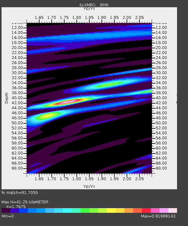
| Estimated Moho Depth: |
41.25 km |
| Estimated Crust Vp/Vs: |
1.77 |
| Assumed Crust Vp: |
6.601 km/s |
| Estimated Crust Vs: |
3.734 km/s |
| Estimated Crust Poisson's Ratio: |
0.26 |
|
| Radial Match: |
91.7055 % |
| Radial Bump: |
386 |
| Transverse Match: |
81.99617 % |
| Transverse Bump: |
400 |
| SOD ConfigId: |
6273 |
| Insert Time: |
2010-03-04 20:25:10.113 +0000 |
| GWidth: |
2.5 |
| Max Bumps: |
400 |
| Tol: |
0.001 |
|

Signal To Noise
| Channel | StoN | STA | LTA |
| IU:KMBO: :BHN:19951018T10:50:06.877026Z | 0.596616 | 1.2675608E-7 | 2.1245839E-7 |
| IU:KMBO: :BHE:19951018T10:50:06.877026Z | 0.48727855 | 9.6603415E-8 | 1.982509E-7 |
| IU:KMBO: :BHZ:19951018T10:50:06.877026Z | 1.1783695 | 8.578325E-8 | 7.279826E-8 |
| Arrivals |
| Ps | 4.9 SECOND |
| PpPs | 17 SECOND |
| PsPs/PpSs | 22 SECOND |


