You are here: Home > Network List > IU - Global Seismograph Network (GSN - IRIS/USGS) Stations List
> Station KMBO Kilima Mbogo, Kenya > Earthquake Result Viewer
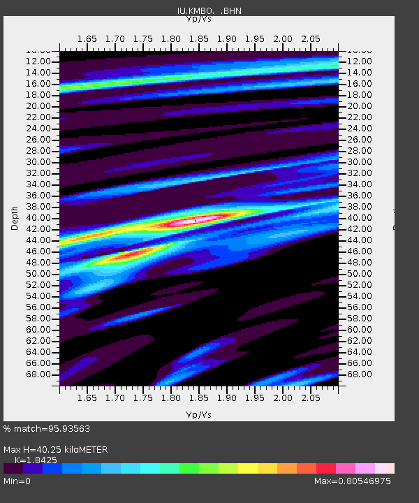
KMBO Kilima Mbogo, Kenya - Earthquake Result Viewer
| Earthquake location: |
Northern Molucca Sea |
| Earthquake latitude/longitude: |
1.7/126.1 |
| Earthquake time(UTC): |
1996/02/28 (059) 09:44:09 GMT |
| Earthquake Depth: |
103 km |
| Earthquake Magnitude: |
6.1 MB, 6.4 UNKNOWN, 6.4 MW |
| Earthquake Catalog/Contributor: |
WHDF/NEIC |
|
| Network: |
IU Global Seismograph Network (GSN - IRIS/USGS) |
| Station: |
KMBO Kilima Mbogo, Kenya |
| Lat/Lon: |
1.13 S/37.25 E |
| Elevation: |
1960 m |
|
| Distance: |
88.9 deg |
| Az: |
268.846 deg |
| Baz: |
88.258 deg |
| Ray Param: |
0.042046644 |
| Estimated Moho Depth: |
40.25 km |
| Estimated Crust Vp/Vs: |
1.84 |
| Assumed Crust Vp: |
6.601 km/s |
| Estimated Crust Vs: |
3.582 km/s |
| Estimated Crust Poisson's Ratio: |
0.29 |
|
| Radial Match: |
95.93563 % |
| Radial Bump: |
377 |
| Transverse Match: |
85.90486 % |
| Transverse Bump: |
400 |
| SOD ConfigId: |
6273 |
| Insert Time: |
2010-03-04 20:25:26.624 +0000 |
| GWidth: |
2.5 |
| Max Bumps: |
400 |
| Tol: |
0.001 |
|

Signal To Noise
| Channel | StoN | STA | LTA |
| IU:KMBO: :BHN:19960228T09:56:20.952002Z | 1.5038518 | 1.4624278E-7 | 9.7245476E-8 |
| IU:KMBO: :BHE:19960228T09:56:20.952002Z | 1.0335357 | 9.697109E-8 | 9.382461E-8 |
| IU:KMBO: :BHZ:19960228T09:56:20.952002Z | 2.1932073 | 1.911247E-7 | 8.714393E-8 |
| Arrivals |
| Ps | 5.2 SECOND |
| PpPs | 17 SECOND |
| PsPs/PpSs | 22 SECOND |


