You are here: Home > Network List > N4 - Central and EAstern US Network Stations List
> Station E38A The Farm, Brule, WI, USA > Earthquake Result Viewer
E38A The Farm, Brule, WI, USA - Earthquake Result Viewer
| Earthquake location: |
Near Coast Of Central Chile |
| Earthquake latitude/longitude: |
-31.7/-71.6 |
| Earthquake time(UTC): |
2015/09/21 (264) 17:39:58 GMT |
| Earthquake Depth: |
25 km |
| Earthquake Magnitude: |
6.5 MB, 6.5 MI, 6.6 MWW |
| Earthquake Catalog/Contributor: |
NEIC PDE/NEIC COMCAT |
|
| Network: |
N4 Central and EAstern US Network |
| Station: |
E38A The Farm, Brule, WI, USA |
| Lat/Lon: |
46.61 N/91.55 W |
| Elevation: |
341 m |
|
| Distance: |
80.0 deg |
| Az: |
346.203 deg |
| Baz: |
162.86 deg |
| Ray Param: |
0.048523888 |
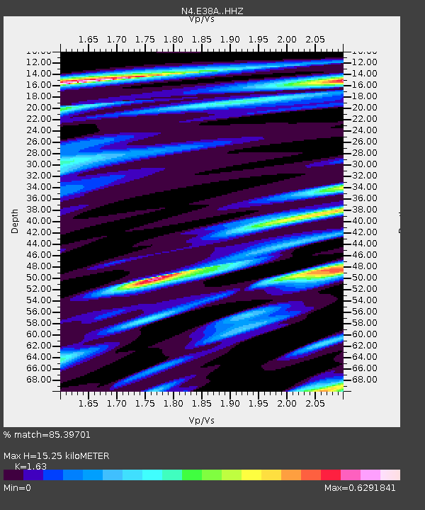
| Estimated Moho Depth: |
15.25 km |
| Estimated Crust Vp/Vs: |
1.63 |
| Assumed Crust Vp: |
6.467 km/s |
| Estimated Crust Vs: |
3.967 km/s |
| Estimated Crust Poisson's Ratio: |
0.20 |
|
| Radial Match: |
85.39701 % |
| Radial Bump: |
400 |
| Transverse Match: |
76.16526 % |
| Transverse Bump: |
400 |
| SOD ConfigId: |
7422571 |
| Insert Time: |
2019-04-20 23:30:39.727 +0000 |
| GWidth: |
2.5 |
| Max Bumps: |
400 |
| Tol: |
0.001 |
|

Signal To Noise
| Channel | StoN | STA | LTA |
| N4:E38A: :HHZ:20150921T17:51:35.140024Z | 15.040594 | 4.305109E-6 | 2.8623265E-7 |
| N4:E38A: :HHN:20150921T17:51:35.140024Z | 3.5933297 | 1.2273271E-6 | 3.4155704E-7 |
| N4:E38A: :HHE:20150921T17:51:35.140024Z | 2.2863688 | 5.657956E-7 | 2.4746467E-7 |
| Arrivals |
| Ps | 1.5 SECOND |
| PpPs | 6.0 SECOND |
| PsPs/PpSs | 7.5 SECOND |


