You are here: Home > Network List > IU - Global Seismograph Network (GSN - IRIS/USGS) Stations List
> Station KMBO Kilima Mbogo, Kenya > Earthquake Result Viewer
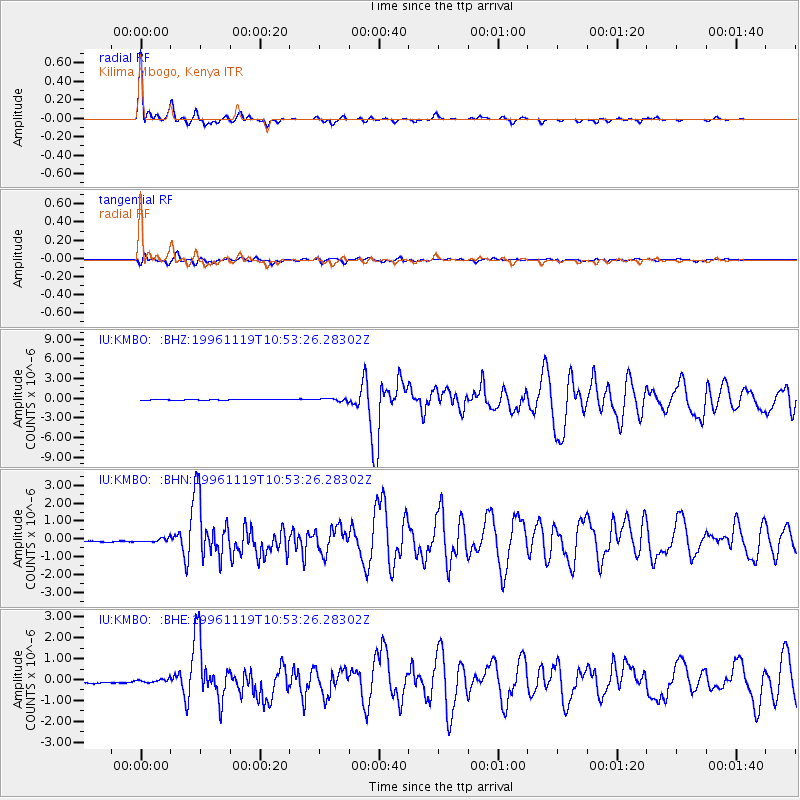
KMBO Kilima Mbogo, Kenya - Earthquake Result Viewer

| Earthquake location: |
Eastern Kashmir |
| Earthquake latitude/longitude: |
35.3/78.1 |
| Earthquake time(UTC): |
1996/11/19 (324) 10:44:46 GMT |
| Earthquake Depth: |
33 km |
| Earthquake Magnitude: |
6.1 MB, 7.1 MS, 6.9 UNKNOWN, 6.8 MW |
| Earthquake Catalog/Contributor: |
WHDF/NEIC |
|
| Network: |
IU Global Seismograph Network (GSN - IRIS/USGS) |
| Station: |
KMBO Kilima Mbogo, Kenya |
| Lat/Lon: |
1.13 S/37.25 E |
| Elevation: |
1960 m |
|
| Distance: |
52.6 deg |
| Az: |
235.406 deg |
| Baz: |
42.307 deg |
| Ray Param: |
0.066565655 |
| Estimated Moho Depth: |
42.5 km |
| Estimated Crust Vp/Vs: |
1.77 |
| Assumed Crust Vp: |
6.601 km/s |
| Estimated Crust Vs: |
3.734 km/s |
| Estimated Crust Poisson's Ratio: |
0.26 |
|
| Radial Match: |
97.33739 % |
| Radial Bump: |
277 |
| Transverse Match: |
87.98651 % |
| Transverse Bump: |
400 |
| SOD ConfigId: |
6273 |
| Insert Time: |
2010-03-04 20:25:43.712 +0000 |
| GWidth: |
2.5 |
| Max Bumps: |
400 |
| Tol: |
0.001 |
|
Signal To Noise
| Channel | StoN | STA | LTA |
| IU:KMBO: :BHN:19961119T10:53:26.28302Z | 1.0334125 | 1.1194612E-7 | 1.0832667E-7 |
| IU:KMBO: :BHE:19961119T10:53:26.28302Z | 0.64422643 | 7.8572164E-8 | 1.2196358E-7 |
| IU:KMBO: :BHZ:19961119T10:53:26.28302Z | 3.0216954 | 2.0023396E-7 | 6.6265436E-8 |
| Arrivals |
| Ps | 5.2 SECOND |
| PpPs | 17 SECOND |
| PsPs/PpSs | 22 SECOND |


