You are here: Home > Network List > N4 - Central and EAstern US Network Stations List
> Station R53A Hurricane, WV, USA > Earthquake Result Viewer
R53A Hurricane, WV, USA - Earthquake Result Viewer
| Earthquake location: |
Near Coast Of Central Chile |
| Earthquake latitude/longitude: |
-31.7/-71.6 |
| Earthquake time(UTC): |
2015/09/21 (264) 17:39:58 GMT |
| Earthquake Depth: |
25 km |
| Earthquake Magnitude: |
6.5 MB, 6.5 MI, 6.6 MWW |
| Earthquake Catalog/Contributor: |
NEIC PDE/NEIC COMCAT |
|
| Network: |
N4 Central and EAstern US Network |
| Station: |
R53A Hurricane, WV, USA |
| Lat/Lon: |
38.33 N/81.95 W |
| Elevation: |
294 m |
|
| Distance: |
70.4 deg |
| Az: |
351.4 deg |
| Baz: |
170.677 deg |
| Ray Param: |
0.054994076 |
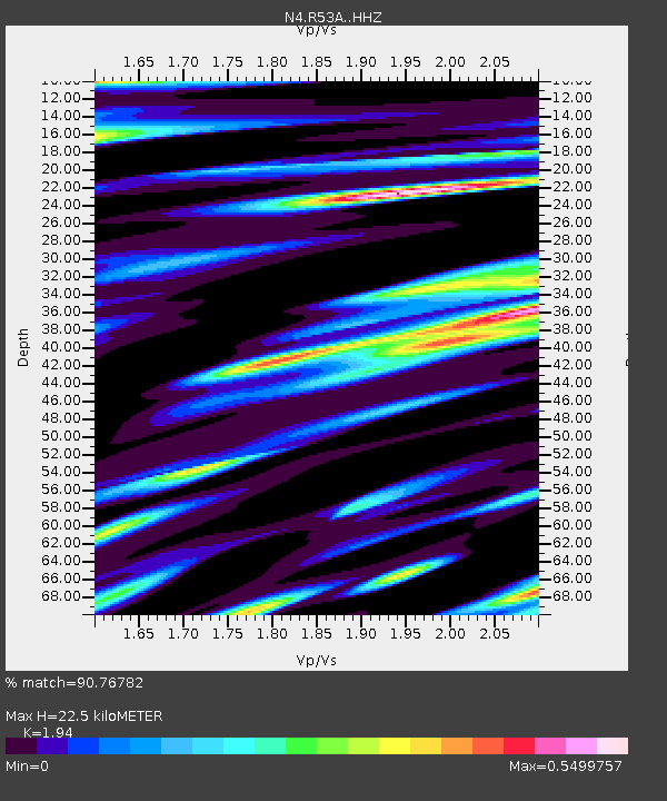
| Estimated Moho Depth: |
22.5 km |
| Estimated Crust Vp/Vs: |
1.94 |
| Assumed Crust Vp: |
6.207 km/s |
| Estimated Crust Vs: |
3.199 km/s |
| Estimated Crust Poisson's Ratio: |
0.32 |
|
| Radial Match: |
90.76782 % |
| Radial Bump: |
400 |
| Transverse Match: |
73.73113 % |
| Transverse Bump: |
400 |
| SOD ConfigId: |
7422571 |
| Insert Time: |
2019-04-20 23:31:37.162 +0000 |
| GWidth: |
2.5 |
| Max Bumps: |
400 |
| Tol: |
0.001 |
|

Signal To Noise
| Channel | StoN | STA | LTA |
| N4:R53A: :HHZ:20150921T17:50:39.630015Z | 18.495415 | 4.112009E-6 | 2.2232585E-7 |
| N4:R53A: :HHN:20150921T17:50:39.630015Z | 7.4106317 | 1.3224858E-6 | 1.784579E-7 |
| N4:R53A: :HHE:20150921T17:50:39.630015Z | 1.2041929 | 2.7120515E-7 | 2.2521736E-7 |
| Arrivals |
| Ps | 3.5 SECOND |
| PpPs | 10 SECOND |
| PsPs/PpSs | 14 SECOND |


