You are here: Home > Network List > IU - Global Seismograph Network (GSN - IRIS/USGS) Stations List
> Station KMBO Kilima Mbogo, Kenya > Earthquake Result Viewer
KMBO Kilima Mbogo, Kenya - Earthquake Result Viewer

| Earthquake location: |
Ionian Sea |
| Earthquake latitude/longitude: |
37.6/20.7 |
| Earthquake time(UTC): |
1997/11/18 (322) 13:07:41 GMT |
| Earthquake Depth: |
33 km |
| Earthquake Magnitude: |
5.9 MB, 6.4 MS, 6.7 UNKNOWN, 6.1 ML |
| Earthquake Catalog/Contributor: |
WHDF/NEIC |
|
| Network: |
IU Global Seismograph Network (GSN - IRIS/USGS) |
| Station: |
KMBO Kilima Mbogo, Kenya |
| Lat/Lon: |
1.13 S/37.25 E |
| Elevation: |
1960 m |
|
| Distance: |
41.5 deg |
| Az: |
154.446 deg |
| Baz: |
339.952 deg |
| Ray Param: |
0.07371389 |
| Estimated Moho Depth: |
43.5 km |
| Estimated Crust Vp/Vs: |
1.66 |
| Assumed Crust Vp: |
6.601 km/s |
| Estimated Crust Vs: |
3.982 km/s |
| Estimated Crust Poisson's Ratio: |
0.21 |
|
| Radial Match: |
93.834496 % |
| Radial Bump: |
343 |
| Transverse Match: |
83.7902 % |
| Transverse Bump: |
400 |
| SOD ConfigId: |
6273 |
| Insert Time: |
2010-03-04 20:26:06.196 +0000 |
| GWidth: |
2.5 |
| Max Bumps: |
400 |
| Tol: |
0.001 |
|
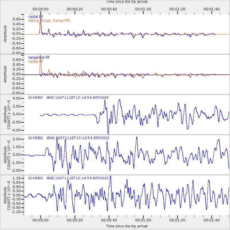
Signal To Noise
| Channel | StoN | STA | LTA |
| IU:KMBO: :BHN:19971118T13:14:54.865009Z | 4.524316 | 4.651899E-7 | 1.02819946E-7 |
| IU:KMBO: :BHE:19971118T13:14:54.865009Z | 3.9229918 | 1.8729837E-7 | 4.7743757E-8 |
| IU:KMBO: :BHZ:19971118T13:14:54.865009Z | 7.491603 | 9.620968E-7 | 1.2842337E-7 |
| Arrivals |
| Ps | 4.7 SECOND |
| PpPs | 16 SECOND |
| PsPs/PpSs | 21 SECOND |


