You are here: Home > Network List > IU - Global Seismograph Network (GSN - IRIS/USGS) Stations List
> Station KMBO Kilima Mbogo, Kenya > Earthquake Result Viewer
KMBO Kilima Mbogo, Kenya - Earthquake Result Viewer
| Earthquake location: |
Mindanao, Philippines |
| Earthquake latitude/longitude: |
8.1/126.3 |
| Earthquake time(UTC): |
1997/03/11 (070) 19:21:23 GMT |
| Earthquake Depth: |
88 km |
| Earthquake Magnitude: |
5.7 MB |
| Earthquake Catalog/Contributor: |
WHDF/NEIC |
|
| Network: |
IU Global Seismograph Network (GSN - IRIS/USGS) |
| Station: |
KMBO Kilima Mbogo, Kenya |
| Lat/Lon: |
1.13 S/37.25 E |
| Elevation: |
1960 m |
|
| Distance: |
89.3 deg |
| Az: |
268.764 deg |
| Baz: |
81.903 deg |
| Ray Param: |
0.04180926 |
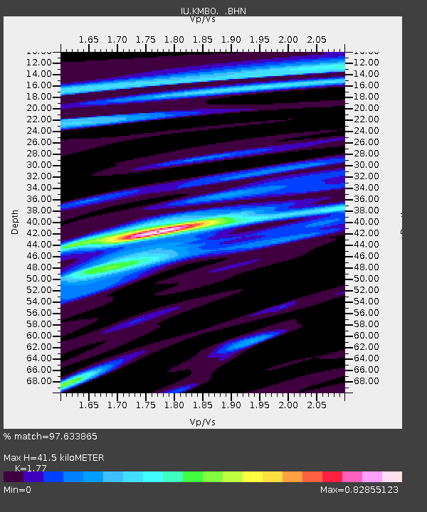
| Estimated Moho Depth: |
41.5 km |
| Estimated Crust Vp/Vs: |
1.77 |
| Assumed Crust Vp: |
6.601 km/s |
| Estimated Crust Vs: |
3.729 km/s |
| Estimated Crust Poisson's Ratio: |
0.27 |
|
| Radial Match: |
97.633865 % |
| Radial Bump: |
318 |
| Transverse Match: |
89.63943 % |
| Transverse Bump: |
400 |
| SOD ConfigId: |
4480 |
| Insert Time: |
2010-03-04 20:26:23.443 +0000 |
| GWidth: |
2.5 |
| Max Bumps: |
400 |
| Tol: |
0.001 |
|

Signal To Noise
| Channel | StoN | STA | LTA |
| IU:KMBO: :BHN:19970311T19:33:38.054016Z | 8.352326 | 5.0885274E-7 | 6.092347E-8 |
| IU:KMBO: :BHE:19970311T19:33:38.054016Z | 1.8004959 | 9.067784E-8 | 5.03627E-8 |
| IU:KMBO: :BHZ:19970311T19:33:38.054016Z | 2.4634733 | 1.6655791E-7 | 6.7611005E-8 |
| Arrivals |
| Ps | 4.9 SECOND |
| PpPs | 17 SECOND |
| PsPs/PpSs | 22 SECOND |


