You are here: Home > Network List > TA - USArray Transportable Network (new EarthScope stations) Stations List
> Station I62A Tamworth, NH, USA > Earthquake Result Viewer
I62A Tamworth, NH, USA - Earthquake Result Viewer
| Earthquake location: |
Near Coast Of Central Chile |
| Earthquake latitude/longitude: |
-31.7/-71.6 |
| Earthquake time(UTC): |
2015/09/21 (264) 17:39:58 GMT |
| Earthquake Depth: |
25 km |
| Earthquake Magnitude: |
6.5 MB, 6.5 MI, 6.6 MWW |
| Earthquake Catalog/Contributor: |
NEIC PDE/NEIC COMCAT |
|
| Network: |
TA USArray Transportable Network (new EarthScope stations) |
| Station: |
I62A Tamworth, NH, USA |
| Lat/Lon: |
43.87 N/71.34 W |
| Elevation: |
264 m |
|
| Distance: |
75.3 deg |
| Az: |
0.224 deg |
| Baz: |
180.264 deg |
| Ray Param: |
0.05176462 |
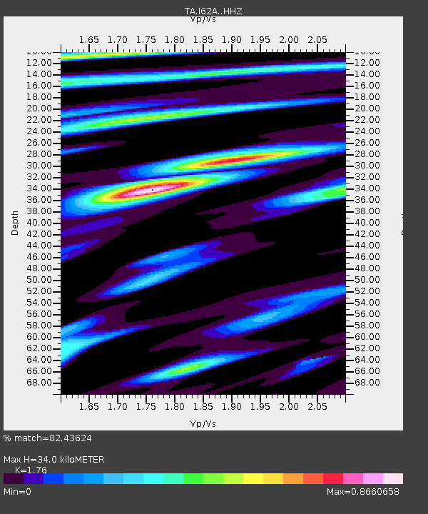
| Estimated Moho Depth: |
34.0 km |
| Estimated Crust Vp/Vs: |
1.76 |
| Assumed Crust Vp: |
6.419 km/s |
| Estimated Crust Vs: |
3.647 km/s |
| Estimated Crust Poisson's Ratio: |
0.26 |
|
| Radial Match: |
82.43624 % |
| Radial Bump: |
373 |
| Transverse Match: |
70.19303 % |
| Transverse Bump: |
400 |
| SOD ConfigId: |
7422571 |
| Insert Time: |
2019-04-20 23:35:00.757 +0000 |
| GWidth: |
2.5 |
| Max Bumps: |
400 |
| Tol: |
0.001 |
|

Signal To Noise
| Channel | StoN | STA | LTA |
| TA:I62A: :HHZ:20150921T17:51:08.270029Z | 8.852917 | 4.9506557E-6 | 5.5921186E-7 |
| TA:I62A: :HHN:20150921T17:51:08.270029Z | 3.4080281 | 1.6096842E-6 | 4.7232126E-7 |
| TA:I62A: :HHE:20150921T17:51:08.270029Z | 1.2006902 | 3.171038E-7 | 2.6410126E-7 |
| Arrivals |
| Ps | 4.2 SECOND |
| PpPs | 14 SECOND |
| PsPs/PpSs | 18 SECOND |


