You are here: Home > Network List > TA - USArray Transportable Network (new EarthScope stations) Stations List
> Station K22A Casper, WY, USA > Earthquake Result Viewer
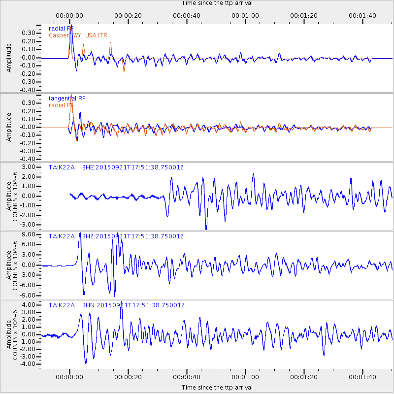
K22A Casper, WY, USA - Earthquake Result Viewer

| Earthquake location: |
Near Coast Of Central Chile |
| Earthquake latitude/longitude: |
-31.7/-71.6 |
| Earthquake time(UTC): |
2015/09/21 (264) 17:39:58 GMT |
| Earthquake Depth: |
25 km |
| Earthquake Magnitude: |
6.5 MB, 6.5 MI, 6.6 MWW |
| Earthquake Catalog/Contributor: |
NEIC PDE/NEIC COMCAT |
|
| Network: |
TA USArray Transportable Network (new EarthScope stations) |
| Station: |
K22A Casper, WY, USA |
| Lat/Lon: |
42.65 N/106.52 W |
| Elevation: |
1686 m |
|
| Distance: |
80.7 deg |
| Az: |
334.681 deg |
| Baz: |
150.405 deg |
| Ray Param: |
0.048093397 |
| Estimated Moho Depth: |
43.25 km |
| Estimated Crust Vp/Vs: |
1.86 |
| Assumed Crust Vp: |
6.178 km/s |
| Estimated Crust Vs: |
3.322 km/s |
| Estimated Crust Poisson's Ratio: |
0.30 |
|
| Radial Match: |
96.46392 % |
| Radial Bump: |
387 |
| Transverse Match: |
90.30969 % |
| Transverse Bump: |
325 |
| SOD ConfigId: |
7422571 |
| Insert Time: |
2019-04-20 23:35:04.960 +0000 |
| GWidth: |
2.5 |
| Max Bumps: |
400 |
| Tol: |
0.001 |
|
Signal To Noise
| Channel | StoN | STA | LTA |
| TA:K22A: :BHZ:20150921T17:51:38.75001Z | 58.277653 | 4.1420426E-6 | 7.107428E-8 |
| TA:K22A: :BHN:20150921T17:51:38.75001Z | 9.678141 | 1.1835671E-6 | 1.2229282E-7 |
| TA:K22A: :BHE:20150921T17:51:38.75001Z | 5.5638146 | 8.2761784E-7 | 1.4875008E-7 |
| Arrivals |
| Ps | 6.2 SECOND |
| PpPs | 20 SECOND |
| PsPs/PpSs | 26 SECOND |


