You are here: Home > Network List > TA - USArray Transportable Network (new EarthScope stations) Stations List
> Station T25A Trinidad, CO, USA > Earthquake Result Viewer
T25A Trinidad, CO, USA - Earthquake Result Viewer
| Earthquake location: |
Near Coast Of Central Chile |
| Earthquake latitude/longitude: |
-31.7/-71.6 |
| Earthquake time(UTC): |
2015/09/21 (264) 17:39:58 GMT |
| Earthquake Depth: |
25 km |
| Earthquake Magnitude: |
6.5 MB, 6.5 MI, 6.6 MWW |
| Earthquake Catalog/Contributor: |
NEIC PDE/NEIC COMCAT |
|
| Network: |
TA USArray Transportable Network (new EarthScope stations) |
| Station: |
T25A Trinidad, CO, USA |
| Lat/Lon: |
37.14 N/104.41 W |
| Elevation: |
2017 m |
|
| Distance: |
75.1 deg |
| Az: |
333.402 deg |
| Baz: |
151.487 deg |
| Ray Param: |
0.05188619 |
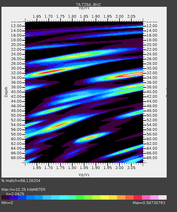
| Estimated Moho Depth: |
32.25 km |
| Estimated Crust Vp/Vs: |
2.06 |
| Assumed Crust Vp: |
6.316 km/s |
| Estimated Crust Vs: |
3.062 km/s |
| Estimated Crust Poisson's Ratio: |
0.35 |
|
| Radial Match: |
96.128204 % |
| Radial Bump: |
339 |
| Transverse Match: |
93.33712 % |
| Transverse Bump: |
380 |
| SOD ConfigId: |
7422571 |
| Insert Time: |
2019-04-20 23:35:35.994 +0000 |
| GWidth: |
2.5 |
| Max Bumps: |
400 |
| Tol: |
0.001 |
|
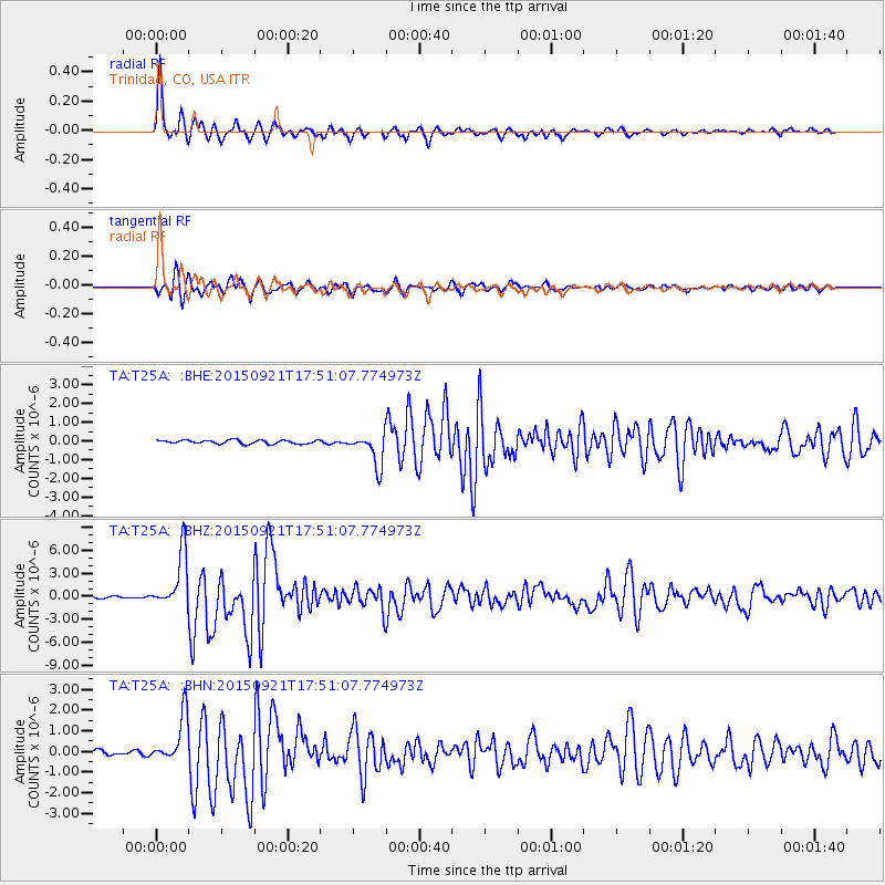
Signal To Noise
| Channel | StoN | STA | LTA |
| TA:T25A: :BHZ:20150921T17:51:07.774973Z | 29.480682 | 3.6021052E-6 | 1.2218527E-7 |
| TA:T25A: :BHN:20150921T17:51:07.774973Z | 11.083504 | 1.1423992E-6 | 1.03072026E-7 |
| TA:T25A: :BHE:20150921T17:51:07.774973Z | 8.662168 | 8.4558616E-7 | 9.761832E-8 |
| Arrivals |
| Ps | 5.6 SECOND |
| PpPs | 15 SECOND |
| PsPs/PpSs | 21 SECOND |


