You are here: Home > Network List > TA - USArray Transportable Network (new EarthScope stations) Stations List
> Station X40A Basin Creek Farm, Marlvern, AR, USA > Earthquake Result Viewer
X40A Basin Creek Farm, Marlvern, AR, USA - Earthquake Result Viewer
| Earthquake location: |
Near Coast Of Central Chile |
| Earthquake latitude/longitude: |
-31.7/-71.6 |
| Earthquake time(UTC): |
2015/09/21 (264) 17:39:58 GMT |
| Earthquake Depth: |
25 km |
| Earthquake Magnitude: |
6.5 MB, 6.5 MI, 6.6 MWW |
| Earthquake Catalog/Contributor: |
NEIC PDE/NEIC COMCAT |
|
| Network: |
TA USArray Transportable Network (new EarthScope stations) |
| Station: |
X40A Basin Creek Farm, Marlvern, AR, USA |
| Lat/Lon: |
34.49 N/92.83 W |
| Elevation: |
158 m |
|
| Distance: |
68.8 deg |
| Az: |
341.319 deg |
| Baz: |
160.708 deg |
| Ray Param: |
0.056012657 |
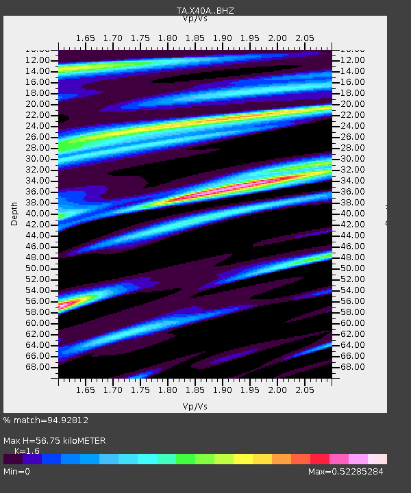
| Estimated Moho Depth: |
56.75 km |
| Estimated Crust Vp/Vs: |
1.60 |
| Assumed Crust Vp: |
6.498 km/s |
| Estimated Crust Vs: |
4.061 km/s |
| Estimated Crust Poisson's Ratio: |
0.18 |
|
| Radial Match: |
94.92812 % |
| Radial Bump: |
400 |
| Transverse Match: |
86.308685 % |
| Transverse Bump: |
400 |
| SOD ConfigId: |
7422571 |
| Insert Time: |
2019-04-20 23:35:42.658 +0000 |
| GWidth: |
2.5 |
| Max Bumps: |
400 |
| Tol: |
0.001 |
|

Signal To Noise
| Channel | StoN | STA | LTA |
| TA:X40A: :BHZ:20150921T17:50:30.398997Z | 24.394663 | 3.2900941E-6 | 1.3486942E-7 |
| TA:X40A: :BHN:20150921T17:50:30.398997Z | 7.7887373 | 7.509015E-7 | 9.640863E-8 |
| TA:X40A: :BHE:20150921T17:50:30.398997Z | 10.15754 | 8.050928E-7 | 7.92606E-8 |
| Arrivals |
| Ps | 5.5 SECOND |
| PpPs | 22 SECOND |
| PsPs/PpSs | 27 SECOND |


