You are here: Home > Network List > UW - Pacific Northwest Regional Seismic Network Stations List
> Station UMAT Pilot Rock, OR, USA > Earthquake Result Viewer
UMAT Pilot Rock, OR, USA - Earthquake Result Viewer
| Earthquake location: |
Near Coast Of Central Chile |
| Earthquake latitude/longitude: |
-31.7/-71.6 |
| Earthquake time(UTC): |
2015/09/21 (264) 17:39:58 GMT |
| Earthquake Depth: |
25 km |
| Earthquake Magnitude: |
6.5 MB, 6.5 MI, 6.6 MWW |
| Earthquake Catalog/Contributor: |
NEIC PDE/NEIC COMCAT |
|
| Network: |
UW Pacific Northwest Regional Seismic Network |
| Station: |
UMAT Pilot Rock, OR, USA |
| Lat/Lon: |
45.29 N/118.96 W |
| Elevation: |
1318 m |
|
| Distance: |
87.9 deg |
| Az: |
328.713 deg |
| Baz: |
141.184 deg |
| Ray Param: |
0.042968147 |
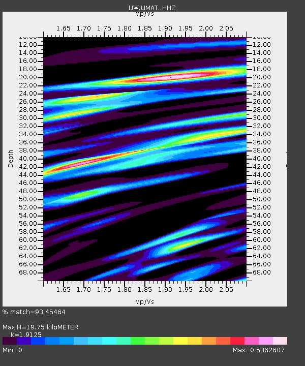
| Estimated Moho Depth: |
19.75 km |
| Estimated Crust Vp/Vs: |
1.91 |
| Assumed Crust Vp: |
6.571 km/s |
| Estimated Crust Vs: |
3.436 km/s |
| Estimated Crust Poisson's Ratio: |
0.31 |
|
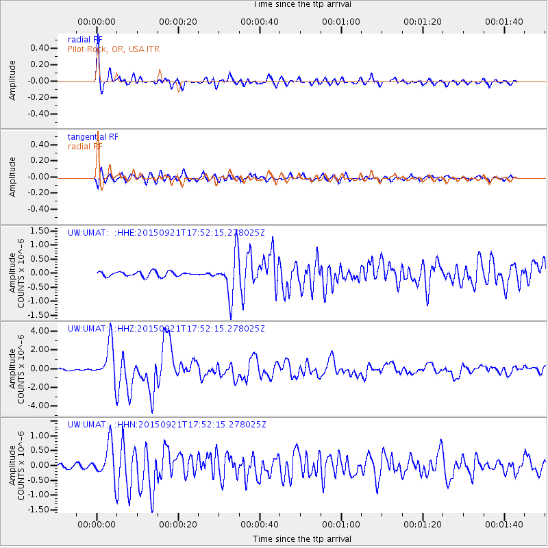
| Radial Match: |
93.45464 % |
| Radial Bump: |
400 |
| Transverse Match: |
86.576126 % |
| Transverse Bump: |
400 |
| SOD ConfigId: |
7422571 |
| Insert Time: |
2019-04-20 23:37:01.776 +0000 |
| GWidth: |
2.5 |
| Max Bumps: |
400 |
| Tol: |
0.001 |
|
Signal To Noise
| Channel | StoN | STA | LTA |
| UW:UMAT: :HHZ:20150921T17:52:15.278025Z | 34.539 | 2.1167639E-6 | 6.1286194E-8 |
| UW:UMAT: :HHN:20150921T17:52:15.278025Z | 8.349089 | 6.27634E-7 | 7.517396E-8 |
| UW:UMAT: :HHE:20150921T17:52:15.278025Z | 8.684112 | 7.358718E-7 | 8.473772E-8 |
| Arrivals |
| Ps | 2.8 SECOND |
| PpPs | 8.6 SECOND |
| PsPs/PpSs | 11 SECOND |


