You are here: Home > Network List > XD14 - Illuminating the architecture of the greater Mount St. Helens magmatic systems f Stations List
> Station ML07 "Mount St Helens, WA" > Earthquake Result Viewer
ML07 "Mount St Helens, WA" - Earthquake Result Viewer
| Earthquake location: |
Near Coast Of Central Chile |
| Earthquake latitude/longitude: |
-31.7/-71.6 |
| Earthquake time(UTC): |
2015/09/21 (264) 17:39:58 GMT |
| Earthquake Depth: |
25 km |
| Earthquake Magnitude: |
6.5 MB, 6.5 MI, 6.6 MWW |
| Earthquake Catalog/Contributor: |
NEIC PDE/NEIC COMCAT |
|
| Network: |
XD Illuminating the architecture of the greater Mount St. Helens magmatic systems f |
| Station: |
ML07 "Mount St Helens, WA" |
| Lat/Lon: |
46.07 N/122.12 W |
| Elevation: |
694 m |
|
| Distance: |
89.9 deg |
| Az: |
327.52 deg |
| Baz: |
138.911 deg |
| Ray Param: |
0.041708536 |
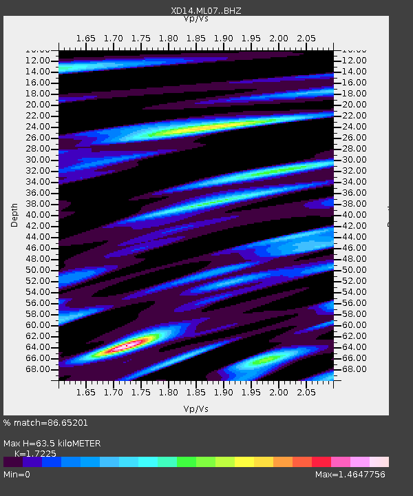
| Estimated Moho Depth: |
63.5 km |
| Estimated Crust Vp/Vs: |
1.72 |
| Assumed Crust Vp: |
6.566 km/s |
| Estimated Crust Vs: |
3.812 km/s |
| Estimated Crust Poisson's Ratio: |
0.25 |
|
| Radial Match: |
86.65201 % |
| Radial Bump: |
400 |
| Transverse Match: |
76.17448 % |
| Transverse Bump: |
400 |
| SOD ConfigId: |
7422571 |
| Insert Time: |
2019-04-20 23:38:07.474 +0000 |
| GWidth: |
2.5 |
| Max Bumps: |
400 |
| Tol: |
0.001 |
|

Signal To Noise
| Channel | StoN | STA | LTA |
| XD:ML07: :BHZ:20150921T17:52:24.770029Z | 16.470192 | 2.5756597E-6 | 1.563831E-7 |
| XD:ML07: :BHN:20150921T17:52:24.770029Z | 2.685753 | 5.754761E-7 | 2.1426992E-7 |
| XD:ML07: :BHE:20150921T17:52:24.770029Z | 5.631394 | 7.6239985E-7 | 1.3538386E-7 |
| Arrivals |
| Ps | 7.1 SECOND |
| PpPs | 26 SECOND |
| PsPs/PpSs | 33 SECOND |


