You are here: Home > Network List > XD14 - Illuminating the architecture of the greater Mount St. Helens magmatic systems f Stations List
> Station MN10 "Mount St Helens, WA" > Earthquake Result Viewer
MN10 "Mount St Helens, WA" - Earthquake Result Viewer
| Earthquake location: |
Near Coast Of Central Chile |
| Earthquake latitude/longitude: |
-31.7/-71.6 |
| Earthquake time(UTC): |
2015/09/21 (264) 17:39:58 GMT |
| Earthquake Depth: |
25 km |
| Earthquake Magnitude: |
6.5 MB, 6.5 MI, 6.6 MWW |
| Earthquake Catalog/Contributor: |
NEIC PDE/NEIC COMCAT |
|
| Network: |
XD Illuminating the architecture of the greater Mount St. Helens magmatic systems f |
| Station: |
MN10 "Mount St Helens, WA" |
| Lat/Lon: |
45.98 N/121.68 W |
| Elevation: |
1091 m |
|
| Distance: |
89.6 deg |
| Az: |
327.688 deg |
| Baz: |
139.223 deg |
| Ray Param: |
0.041727684 |
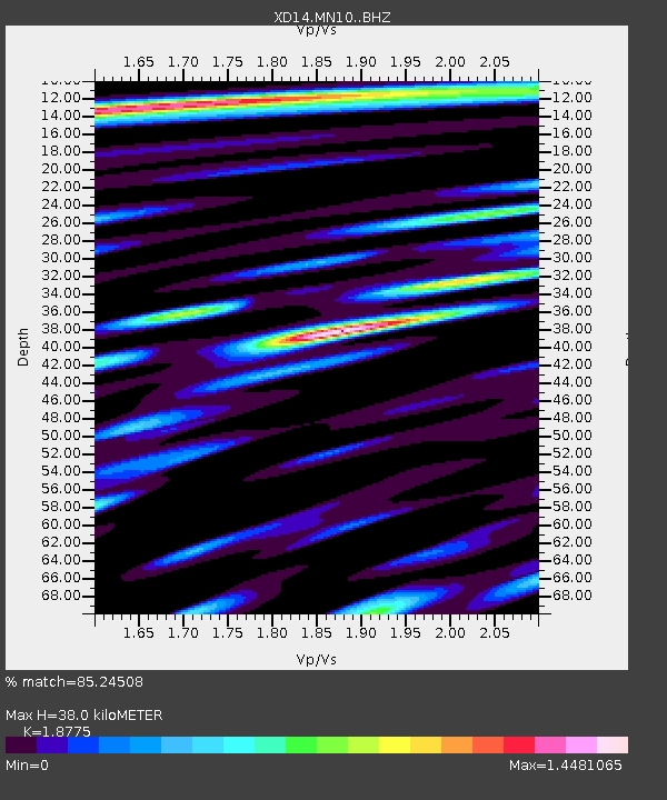
| Estimated Moho Depth: |
38.0 km |
| Estimated Crust Vp/Vs: |
1.88 |
| Assumed Crust Vp: |
6.597 km/s |
| Estimated Crust Vs: |
3.514 km/s |
| Estimated Crust Poisson's Ratio: |
0.30 |
|
| Radial Match: |
85.24508 % |
| Radial Bump: |
400 |
| Transverse Match: |
76.47718 % |
| Transverse Bump: |
400 |
| SOD ConfigId: |
7422571 |
| Insert Time: |
2019-04-20 23:38:13.822 +0000 |
| GWidth: |
2.5 |
| Max Bumps: |
400 |
| Tol: |
0.001 |
|

Signal To Noise
| Channel | StoN | STA | LTA |
| XD:MN10: :BHZ:20150921T17:52:23.520029Z | 14.420551 | 2.587071E-6 | 1.7940167E-7 |
| XD:MN10: :BHN:20150921T17:52:23.520029Z | 1.864382 | 3.954844E-7 | 2.1212627E-7 |
| XD:MN10: :BHE:20150921T17:52:23.520029Z | 1.946546 | 4.1131207E-7 | 2.1130354E-7 |
| Arrivals |
| Ps | 5.2 SECOND |
| PpPs | 16 SECOND |
| PsPs/PpSs | 21 SECOND |


