You are here: Home > Network List > TA - USArray Transportable Network (new EarthScope stations) Stations List
> Station H17A Grant Village (NPS), Yellowstone Nt. Park, WY, USA > Earthquake Result Viewer
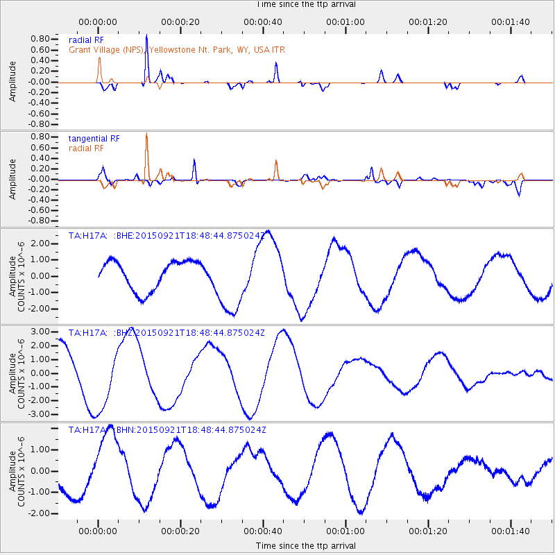
H17A Grant Village (NPS), Yellowstone Nt. Park, WY, USA - Earthquake Result Viewer
*The percent match for this event was below the threshold and hence no stack was calculated.
| Earthquake location: |
Near Coast Of Central Chile |
| Earthquake latitude/longitude: |
-31.1/-71.8 |
| Earthquake time(UTC): |
2015/09/21 (264) 18:36:50 GMT |
| Earthquake Depth: |
10 km |
| Earthquake Magnitude: |
5.7 MB |
| Earthquake Catalog/Contributor: |
NEIC PDE/NEIC ALERT |
|
| Network: |
TA USArray Transportable Network (new EarthScope stations) |
| Station: |
H17A Grant Village (NPS), Yellowstone Nt. Park, WY, USA |
| Lat/Lon: |
44.40 N/110.58 W |
| Elevation: |
2400 m |
|
| Distance: |
83.0 deg |
| Az: |
333.1 deg |
| Baz: |
147.208 deg |
| Ray Param: |
$rayparam |
*The percent match for this event was below the threshold and hence was not used in the summary stack. |
|
| Radial Match: |
95.849686 % |
| Radial Bump: |
257 |
| Transverse Match: |
79.447205 % |
| Transverse Bump: |
400 |
| SOD ConfigId: |
7422571 |
| Insert Time: |
2019-04-20 23:44:26.140 +0000 |
| GWidth: |
2.5 |
| Max Bumps: |
400 |
| Tol: |
0.001 |
|
Signal To Noise
| Channel | StoN | STA | LTA |
| TA:H17A: :BHZ:20150921T18:48:44.875024Z | 1.8433192 | 2.3982582E-6 | 1.3010542E-6 |
| TA:H17A: :BHN:20150921T18:48:44.875024Z | 2.9833 | 1.6768213E-6 | 5.6206926E-7 |
| TA:H17A: :BHE:20150921T18:48:44.875024Z | 2.378748 | 2.0857976E-6 | 8.768468E-7 |
| Arrivals |
| Ps | |
| PpPs | |
| PsPs/PpSs | |


