You are here: Home > Network List > IU - Global Seismograph Network (GSN - IRIS/USGS) Stations List
> Station SDV Santo Domingo, Venezuela > Earthquake Result Viewer
SDV Santo Domingo, Venezuela - Earthquake Result Viewer
| Earthquake location: |
Gulf Of California |
| Earthquake latitude/longitude: |
23.3/-108.5 |
| Earthquake time(UTC): |
2002/10/03 (276) 16:08:29 GMT |
| Earthquake Depth: |
10 km |
| Earthquake Magnitude: |
5.4 MB, 6.2 MS, 6.5 MW, 6.4 MW |
| Earthquake Catalog/Contributor: |
WHDF/NEIC |
|
| Network: |
IU Global Seismograph Network (GSN - IRIS/USGS) |
| Station: |
SDV Santo Domingo, Venezuela |
| Lat/Lon: |
8.88 N/70.63 W |
| Elevation: |
1618 m |
|
| Distance: |
39.0 deg |
| Az: |
105.293 deg |
| Baz: |
296.192 deg |
| Ray Param: |
0.07524075 |
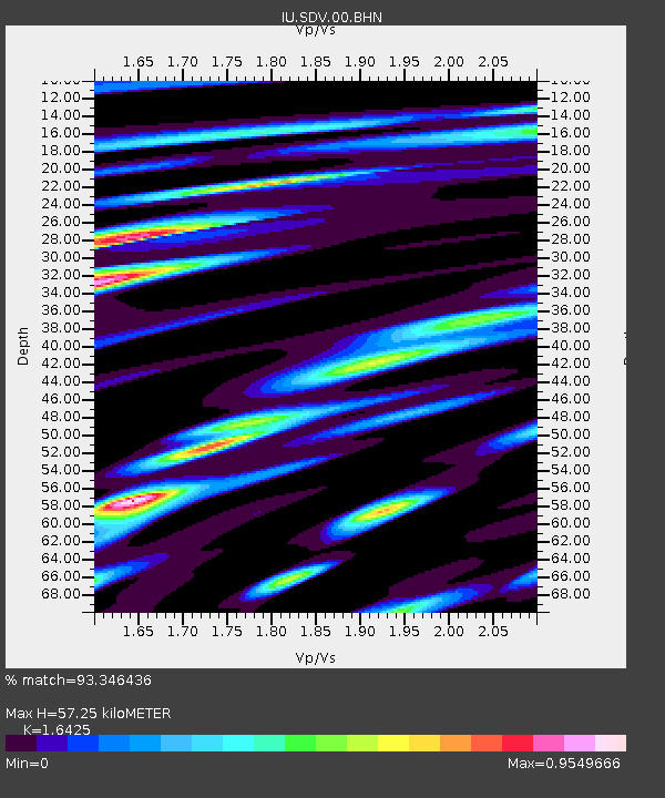
| Estimated Moho Depth: |
57.25 km |
| Estimated Crust Vp/Vs: |
1.64 |
| Assumed Crust Vp: |
6.192 km/s |
| Estimated Crust Vs: |
3.77 km/s |
| Estimated Crust Poisson's Ratio: |
0.21 |
|
| Radial Match: |
93.346436 % |
| Radial Bump: |
400 |
| Transverse Match: |
80.88327 % |
| Transverse Bump: |
400 |
| SOD ConfigId: |
4714 |
| Insert Time: |
2010-03-04 20:29:03.091 +0000 |
| GWidth: |
2.5 |
| Max Bumps: |
400 |
| Tol: |
0.001 |
|
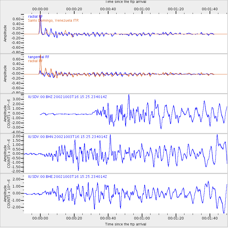
Signal To Noise
| Channel | StoN | STA | LTA |
| IU:SDV:00:BHN:20021003T16:15:25.234014Z | 2.6680818 | 1.390955E-7 | 5.2133146E-8 |
| IU:SDV:00:BHE:20021003T16:15:25.234014Z | 3.7957785 | 1.8653247E-7 | 4.9142084E-8 |
| IU:SDV:00:BHZ:20021003T16:15:25.234014Z | 5.4097238 | 4.1529705E-7 | 7.676863E-8 |
| Arrivals |
| Ps | 6.4 SECOND |
| PpPs | 23 SECOND |
| PsPs/PpSs | 29 SECOND |


