
Station 2B LNDFL - Fenner, NY
Network: 2B - Pryor:Cornell University
Nearby stations (2 deg radius)
| Station | Name | (Lat, Lon) | Start / End | Elevation |
| LNDFL | Fenner, NY | (42.98, -75.77) | 2016-08-24 / 2016-09-23 | 496 m |
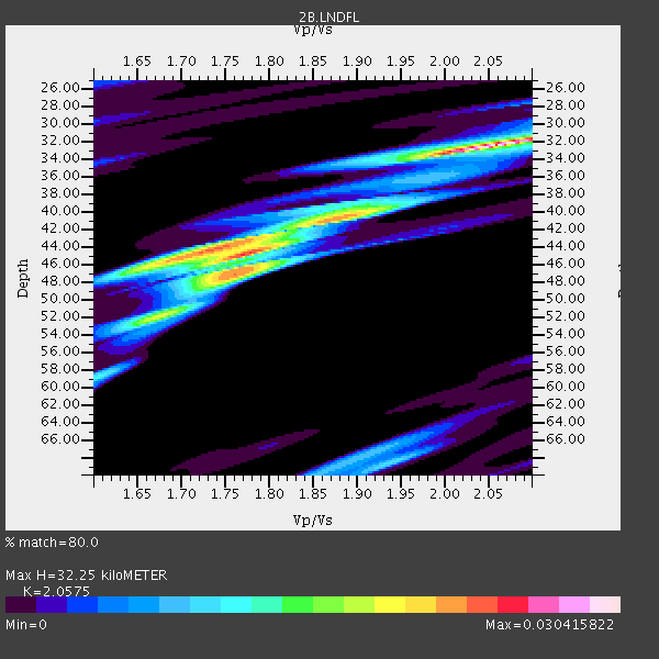
| Crust2 Type: | Q2,orogen/39km no ice, Appalachians, North Andes, 0.5 km seds. |
| Thickness Estimate: | 32 km |
| Thickness StdDev: | 6.6 km |
| Vp/Vs Estimate: | 2.06 |
| Vp/Vs StdDev: | 0.16 |
| Vs Estimate: | 3.12 km/s |
| Poisson's Ratio: | 0.35 |
| Peak Value: | 0.03 |
| Assumed Vp: | 6.419 km/s |
| Ps Weight: | 0.33333334 |
| PpPs Weight: | 0.33333334 |
| PsPs Weight: | 0.33333328 |
| Residual Complexity: | 0.795 |
| Nearby stations H: | +- |
| (2.0 deg) Vp/Vs: | +- |
1 with match > 90% ( 20.0 %) and 2 with match > 80% ( 40.0 %) out of 5.
Download stack as xyz text file.
Azimuth Distribution of Events:

Prior Results for this Station
| Study | Thickness | Vp/Vs | Vp | Vs | Poissons Ratio | Extra |
| EARS | 32 km | 2.06 | 6.419 km/s | 3.12 km/s | 0.35 | |
| Crust2.0 | 39 km | 1.75 | 6.419 km/s | 3.659 km/s | 0.26 | Q2,orogen/39km no ice, Appalachians, North Andes, 0.5 km seds. |
| Global Maxima | 32 km | 2.06 | 6.419 km/s | 3.12 km/s | 0.35 | amp=0.030415822 |
| Local Maxima 1 | 44 km | 1.78 | 6.419 km/s | 3.611 km/s | 0.27 | amp=0.02348331 |
| Local Maxima 2 | 47 km | 1.76 | 6.419 km/s | 3.642 km/s | 0.26 | amp=0.017519932 |
| Local Maxima 3 | 44 km | 1.72 | 6.419 km/s | 3.743 km/s | 0.24 | amp=0.016064428 |
| Local Maxima 4 | 40 km | 1.91 | 6.419 km/s | 3.365 km/s | 0.31 | amp=0.011593204 |
| Predicted Arrivals for vertical incidence (zero ray parameter) | |
| Ps | 5.31 SECOND |
| PpPs | 15.36 SECOND |
| PsPs/PpSs | 20.67 SECOND |
Events Processed for this Station
Download zip of receiver functions as SAC
Plot maxima for each earthquake.
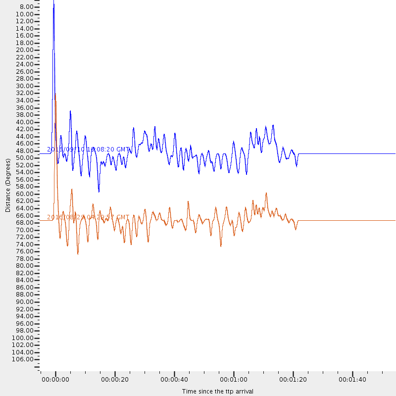
Events Used in the Stack
(2 events)| Radial Match | Distance | Baz | FERegion | Time | Lat/Lon | Depth | Magnitude |
| 92.98151 | 67.1 deg | 113.082 deg | North Of Ascension Island | 2016/08/29 04:29:57 GMT | (-0.0, -17.8) | 10 km | 7.1 MWW, 7.1 MWC, 7.4 MI |
| 81.85066 | 48.3 deg | 181.594 deg | Northern Peru | 2016/09/10 10:08:20 GMT | (-5.6, -77.0) | 114 km | 6.0 MB |
Losers
(3 events)| Radial Match | Distance | Baz | FERegion | Time | Lat/Lon | Depth | Magnitude | Reason |
| 70.632195 | 36.9 deg | 283.472 deg | Off Coast Of Northern California | 2016/09/03 03:27:55 GMT | (40.4, -125.7) | 2.2 km | 5.6 MW, 5.6 MW, 5.7 MI, 5.7 MWP | |
| 69.88464 | 35.5 deg | 180.567 deg | Northern Colombia | 2016/09/14 01:58:30 GMT | (7.3, -76.1) | 10 km | 5.9 MWP | |
| 44.668537 | 74.6 deg | 171.121 deg | Cordoba Province, Argentina | 2016/09/09 00:03:43 GMT | (-31.4, -65.7) | 151 km | 5.6 MWR |

