
Station 2B TWNOF - Fenner, NY
Network: 2B - Pryor:Cornell University
Nearby stations (2 deg radius)
| Station | Name | (Lat, Lon) | Start / End | Elevation |
| TWNOF | Fenner, NY | (42.97, -75.79) | 2016-08-24 / 2016-09-23 | 472 m |
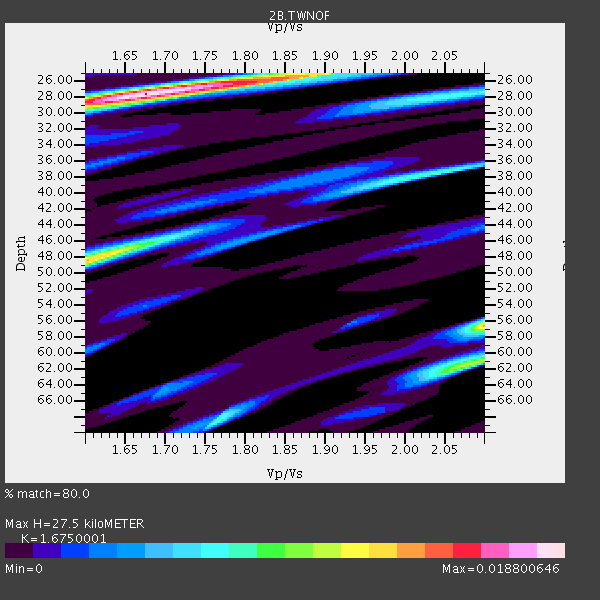
| Crust2 Type: | Q2,orogen/39km no ice, Appalachians, North Andes, 0.5 km seds. |
| Thickness Estimate: | 28 km |
| Thickness StdDev: | 10 km |
| Vp/Vs Estimate: | 1.68 |
| Vp/Vs StdDev: | 0.20 |
| Vs Estimate: | 3.832 km/s |
| Poisson's Ratio: | 0.22 |
| Peak Value: | 0.02 |
| Assumed Vp: | 6.419 km/s |
| Ps Weight: | 0.33333334 |
| PpPs Weight: | 0.33333334 |
| PsPs Weight: | 0.33333328 |
| Residual Complexity: | 0.614 |
| Nearby stations H: | +- |
| (2.0 deg) Vp/Vs: | +- |
1 with match > 90% ( 20.0 %) and 3 with match > 80% ( 60.0 %) out of 5.
Download stack as xyz text file.
Azimuth Distribution of Events:

Prior Results for this Station
| Study | Thickness | Vp/Vs | Vp | Vs | Poissons Ratio | Extra |
| EARS | 28 km | 1.68 | 6.419 km/s | 3.832 km/s | 0.22 | |
| Crust2.0 | 39 km | 1.75 | 6.419 km/s | 3.659 km/s | 0.26 | Q2,orogen/39km no ice, Appalachians, North Andes, 0.5 km seds. |
| Global Maxima | 28 km | 1.68 | 6.419 km/s | 3.832 km/s | 0.22 | amp=0.018800646 |
| Local Maxima 1 | 56 km | 2.10 | 6.419 km/s | 3.06 km/s | 0.35 | amp=0.013294648 |
| Local Maxima 2 | 48 km | 1.60 | 6.419 km/s | 4.006 km/s | 0.18 | amp=0.0131628215 |
| Local Maxima 3 | 61 km | 2.08 | 6.419 km/s | 3.086 km/s | 0.35 | amp=0.010328963 |
| Local Maxima 4 | 38 km | 2.03 | 6.419 km/s | 3.166 km/s | 0.34 | amp=0.007911446 |
| Predicted Arrivals for vertical incidence (zero ray parameter) | |
| Ps | 2.89 SECOND |
| PpPs | 11.46 SECOND |
| PsPs/PpSs | 14.35 SECOND |
Events Processed for this Station
Download zip of receiver functions as SAC
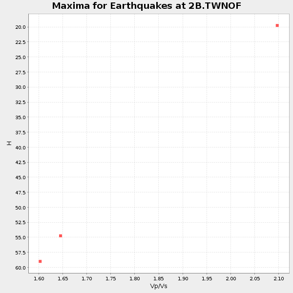
Plot maxima for each earthquake.
Events Used in the Stack
(3 events)| Radial Match | Distance | Baz | FERegion | Time | Lat/Lon | Depth | Magnitude |
| 95.123184 | 67.1 deg | 113.065 deg | North Of Ascension Island | 2016/08/29 04:29:57 GMT | (-0.0, -17.8) | 10 km | 7.1 MWW, 7.1 MWC, 7.4 MI |
| 88.142136 | 48.3 deg | 181.57 deg | Northern Peru | 2016/09/10 10:08:20 GMT | (-5.6, -77.0) | 114 km | 6.0 MB |
| 80.69482 | 36.9 deg | 283.474 deg | Off Coast Of Northern California | 2016/09/03 03:27:55 GMT | (40.4, -125.7) | 2.2 km | 5.6 MW, 5.6 MW, 5.7 MI, 5.7 MWP |
Losers
(2 events)| Radial Match | Distance | Baz | FERegion | Time | Lat/Lon | Depth | Magnitude | Reason |
| 66.42671 | 35.5 deg | 180.536 deg | Northern Colombia | 2016/09/14 01:58:30 GMT | (7.3, -76.1) | 10 km | 5.9 MWP | |
| 46.54395 | 31.8 deg | 200.41 deg | Nicaragua | 2016/09/15 05:57:24 GMT | (12.4, -86.6) | 10 km | 5.7 mww |

